Multi-Scale MJO Research Page
What is the Madden-Julian Oscillation (MJO)?
The MJO is a large tropical convective-circulation system that forms every one to three months (intraseasonal) over the Indian Ocean to West Pacific Ocean warm pool region. The MJO serves as a bridge between weather and climate due to its intraseasonal time scales and its influence on weather and climate phenomena such as El Niño-Southern Oscillation, tropical cyclones, monsoons, tropical convection, and extratropical weather systems. The MJO’s convection typically initiates over the west-central Indian Ocean and propagates slowly eastward at 5 m/s across the Indian Ocean through the West Pacific Ocean. As the MJO propagates eastward across the Pacific, it often decouples from its convection and speeds up while maintaining its large-scale circulation. The MJO can even circle the globe before reinitiating over the Indian Ocean.
Why we are researching the MJO
- The MJO is poorly represented by weather and climate models, often initiating over the Indian Ocean and instead of propagating eastward as observed, it is stationary or propagates westward (e.g., Kim et al. 2018).
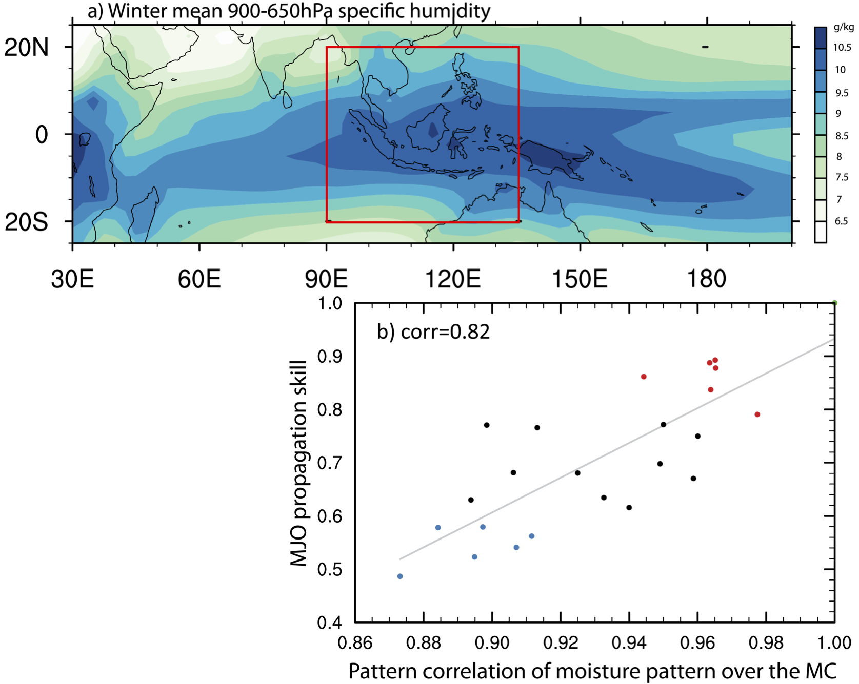
- Recent advancements in understanding MJO physics have pointed to important interactions between the MJO and the seasonally varying moisture and east-west winds surrounding the Maritime Continent (e.g., Gonzalez and Jiang 2017).
- Our group’s research is focused on improving our understanding of the MJO’s interactions with the atmospheric and oceanic mean state in addition to the MJO’s relationship with other equatorial waves (e.g., equatorial Rossby waves and Kelvin waves).
- Our ultimate goal is to improve the accuracy of climate models so that scientists can 1) improve subseasonal and seasonal forecasting and 2) better communicate the anticipated effects of climate change.
Project 1: Multi-scale interactions between between the MJO and equatorial waves
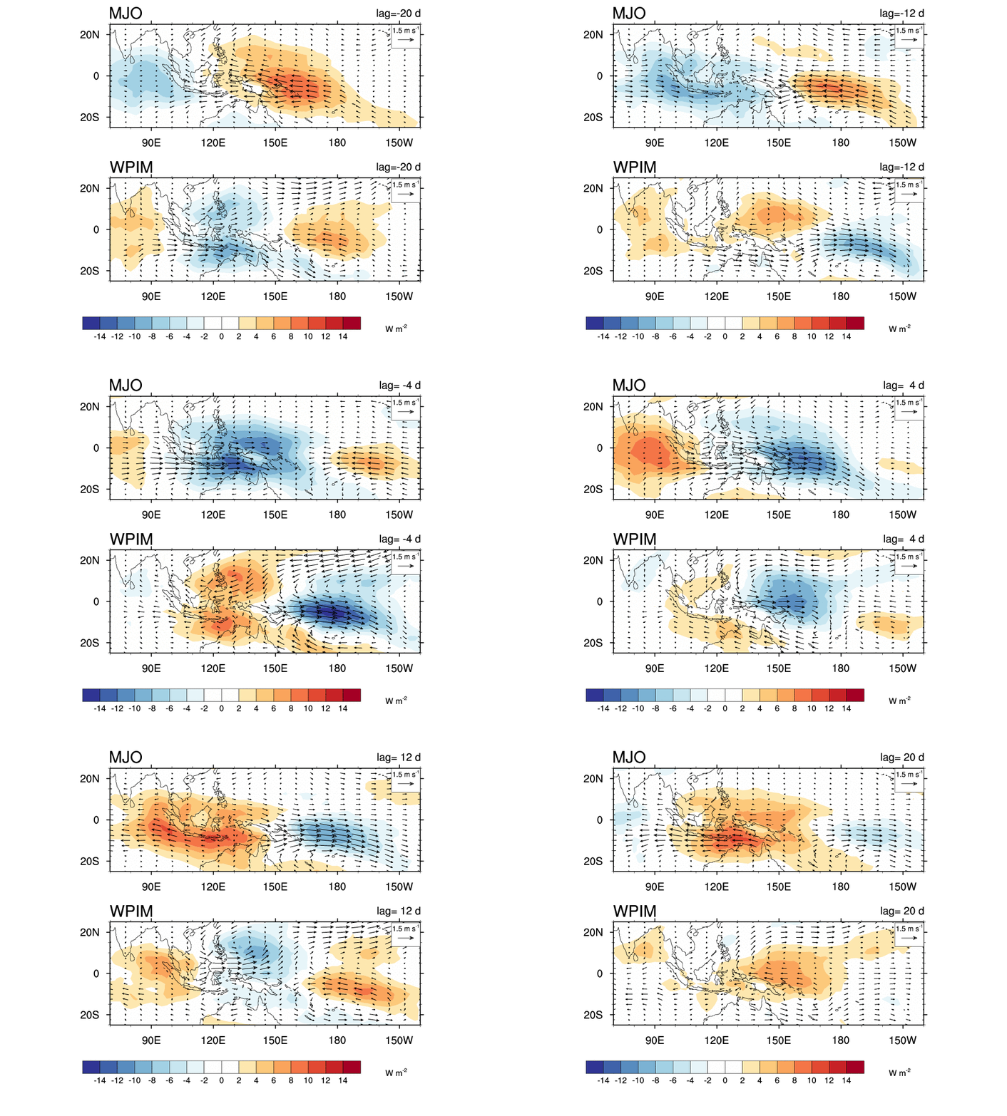
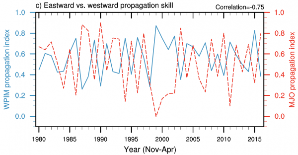
There is growing evidence that the MJO’s observed eastward propagation is not only impacted by the mean state but so are westward propagating equatorial Rossby waves, which span a wide range of time scales (one week to two months). Both the MJO and equatorial Rossby waves (westward propagating intraseasonal mode, WPIM) are active over the Indian Ocean to West Pacific warm pool region, which can lead to a seesaw in their boreal winter and spring activity, as shown in the figures below from Gonzalez and Jiang 2019.
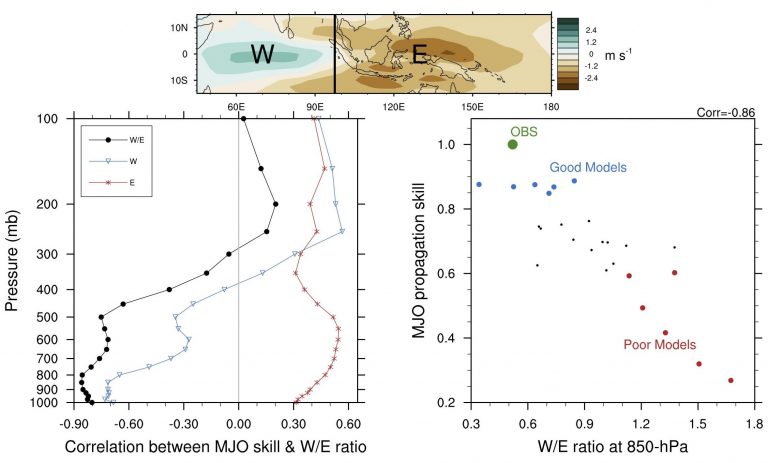
One of our goals is to better understand how climate models represent the MJO and equatorial Rossby waves on intraseasonal time scales, especially the interactions between the two. It has been shown that climate models that struggle with the MJO overproduce east-west winds associated with equatorial Rossby waves leading leading to a biased east-west asymmetry in large-scale circulation (e.g., Wang and Lee 2017).
We have developed a new west/east (W/E) zonal wind speed ratio (Heath et al., 2021); it is similar to what has been used in recent studies to study how large-scale dynamics impact MJO propagation (e.g., B. Wang et al., 2018; L. Wang et al., 2018), with three main distinctions: (1) this W/E ratio is not computed over fixed regions west and east of convection, (2) this W/E ratio takes the vorticity associated with ER waves into account as it averages zonal wind speeds on both sides of the convection, and (3) this W/E ratio can be computed at upper levels. Our W/E ratio has very strong anticorrelations with MJO propagation skill above 0.8 in magnitude from 400 to 1000-hPa. We have found that poor MJO models tend to overproduce westerly (eastward) winds, low-level convergence, and atmospheric heating at low levels (800–1000 hPa). These biases appear to be related to equatorial Rossby waves, however, more work must be done to solidify our understanding.
Further research in this area aims to better understand the how different three-dimensional shapes of atmospheric heating and convection affect the response of the large-scale winds in relation to the MJO’s basic asymmetries using idealized climate models. The ultimate goal is to aid in parameterizing atmospheric convection in climate models. Classic studies using idealized model atmospheric heating show strong evidence that the atmospheric circulation is quite sensitive to the horizontal (Phlips and Gill, 1987) and vertical structure (Wu et al. 2000) of convection.
*This work is/was supported by Iowa State University startup funding and WHOI Independent Research & Development award 52100182.


