ITCZ Dynamics Research Page
What is the ITCZ?
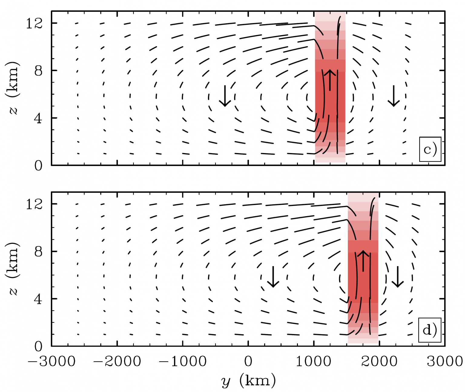
The Inter-Tropical Convergence Zone is a persistent, east-west elongated band of intense rising atmospheric motions, clouds, and precipitation that often wraps around the globe. The ITCZ is central to the global climate system as it serves as the rising branch of the Hadley circulation, a latitude vs. height circulation that transports energy, momentum, and moisture to higher latitudes (see figure of an idealized model below, Gonzalez and Mora Rojas, 2014). The ITCZ is also a key component to the development of tropical cyclones, El Niño-Southern Oscillation, and monsoon systems, as seen in the video below. Classic textbook definitions of the ITCZ describe the ITCZ as following the sun’s seasonal migration but in reality, this is only true over land and the situation is more complicated over ocean.
Why we are researching the ITCZ
- Climate models struggle to correctly simulate the oceanic ITCZ (e.g., Adam et al., 2017), which has limited our ability to fully understand and communicate how the atmosphere and ocean will respond to climate change.
- Our group’s research is focused on better understanding the fundamental physics that explains the weather in and near the ITCZ through detailed examinations of observations, reanalyses, and models of varying complexity.
- Our ultimate goal is to improve the accuracy of climate models so that scientists can 1) improve subseasonal and seasonal forecasting and 2) better communicate the anticipated effects of climate change.
Project 1: Nonlinear Dynamics of boreal spring ITCZ shifts
Our recent work has shown that the ITCZ’s latitudinal location can be explained by an idealized two-dimensional (time & latitude) atmospheric model near Earth’s surface (e.g., Gonzalez et al., 2016). A key component to the model is the inclusion of nonlinear dynamical (velocity) terms that have often been left out of idealized tropical models. These nonlinear terms are particularly important for the eastern Pacific ITCZ, as shown in the figure to the right (Gonzalez and Schubert, 2019).
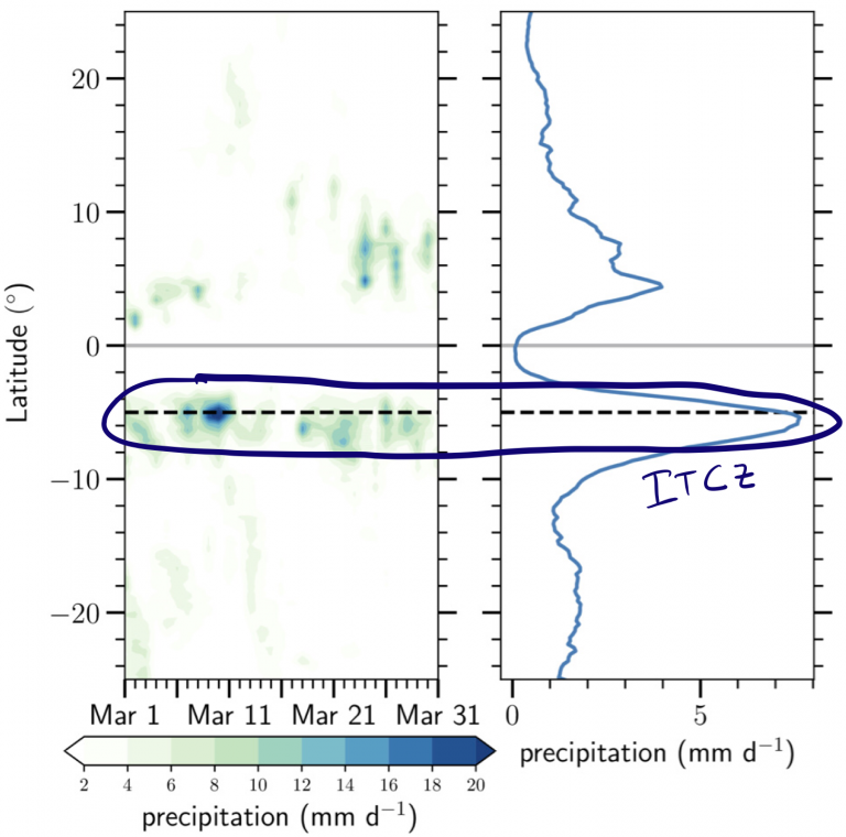
We have found that the time evolution of the north-south surface winds is critical to understanding the observed behavior of the eastern Pacific ITCZ and how it can shift hemispheres or split apart during February through April (Haffke et al. 2016). A recent example of this erratic ITCZ behavior that occurred during March 2018 is shown below, when the ITCZ went from south of the equator to a double ITCZ (both hemispheres) to an ITCZ north of the equator.
A key step to mitigating climate model ITCZ biases is to better understand these rapid ITCZ shifts and splits, particularly for the two most common ITCZ setups in the eastern Pacific Ocean, the northern hemisphere ITCZ and double ITCZ. In this project, our group is investigating the time evolution of numerous variables (winds, temperature, surface fluxes, moisture, etc.) leading up to the northern hemisphere ITCZ and double ITCZ using high-resolution observational data, reanalyses, and our idealized two-dimensional (time & latitude) model.
Project 2: Mitigating ITCZ climate model biases through hindcast simulations
ITCZ accuracy in climate models is typically assessed by computing monthly or seasonal averages, however, it is possible that model biases begin to develop at shorter timescales. This is particularly relevant for the eastern Pacific Ocean, whose ITCZ biases tend occur in the months surrounding February–April, which are the months when the ITCZ experiences to shifts or splits in observations.
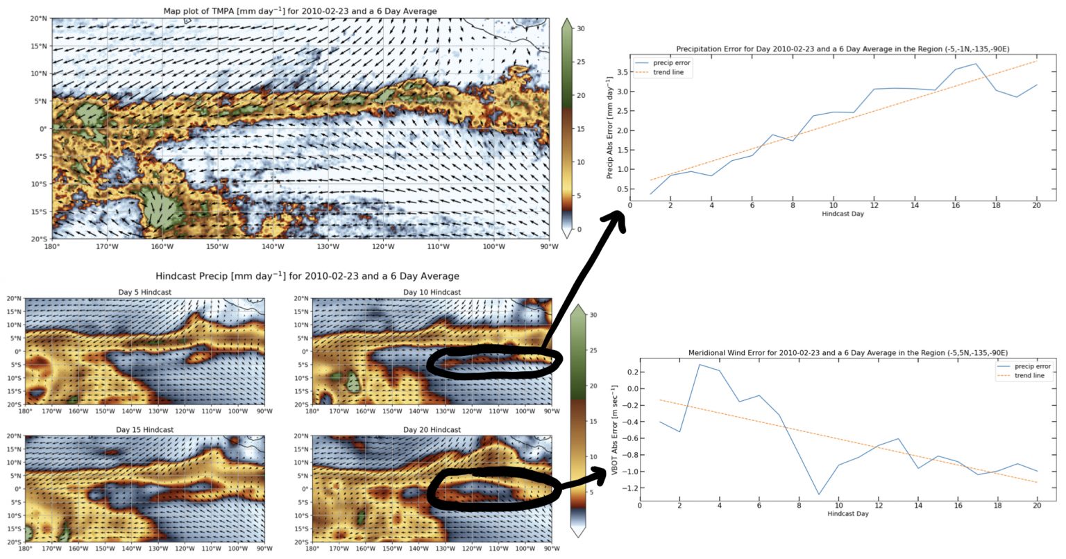
We are investigating the submonthly variability of the eastern Pacific Ocean ITCZ in climate models by running them in “hindcast” mode. A hindcast is a forecast of past weather conditions using an updated (current) model. Running a climate model in hindcast mode is a relatively new concept as climate model simulations are typically not expected to accurately predict weather conditions (see Climate.gov article). With the idea that weather in and near the ITCZ actually matters to the average ITCZ behavior, hindcast simulations may be the best way to illustrate how and why ITCZ biases creep up.
Hindcast simulations using the Community Atmosphere Model (CAM) version 5.3 demonstrate how fast ITCZ biases develop for many ITCZ precipitation events, such as the February 23–28 ITCZ event shown above. There is a gradual development of southern hemisphere ITCZ precipitation (top right) and cross-equatorial wind speed (bottom right) over the 20 day hindcasts. Figures produced by James Larson.
*This work is/was funded by National Science Foundation under grants AGS-1250966, AGS-1546610, AGS-1953944, and under the Science and Technology Center for Multi-Scale Modeling of Atmospheric Processes, managed by Colorado State University through cooperative agreement ATM-0425247. James Larson (now at Colorado State University) received funding from Iowa Space Grant Consortium for his work.


