Global bedrock geology
Mark and I have been using GIS technology to quantify the distribution of bedrock lithology at a scale of individual river drainage basins, continent-scale drainage basins, and the entire Earth surface. We use modern digital maps of bedrock geology to calculate the abundance of major lithologic units (stratified sediments, continental sediments, intercalated sediments and volcanics, volcanic rocks, intrusive rocks, ultramafic rocks and metamorphic rocks) and their age distribution. While data for the distribution of bedrock lithology is available at a coarse scale (1 degree grid), a quantitiative investigation of the age distribution of bedrock is missing.
Our data for North America (Peucker-Ehrenbrink & Miller, 2002, G-cubed 3, doi: 10.1029/2002GC000366; Peucker-Ehrenbrink & Miller, 2003, G-cubed 4, doi: 10.1029/2003GC000449), East and Southeast Asia (Peucker-Ehrenbrink & Miller, 2004, G-cubed 5, doi: 10.1029/2003GC000619) and Brazil (Peucker-Ehrenbrink & Miller, 2007, G-cubed 19, doi: 10.1029/2003GC001505) are at least one order of magnitude more detailed (about 15 minute grid) and are sufficient to investigate medium-sized drainage basins (several thousand square kilometers). We are currently exploring the links between bedrock geology and river chemistry, and are building a digital database of bedrock geology of major river basins worlwide (Peucker-Ehrenbrink & Miller, 2007, G-cubed 10, doi: 10.1029/2003GC001544).
This WHOI- and NSF-supported research has led to a geology-based parameterization of radiogenic (Sr and Nd) isotope composition of continental runoff on global, regional and global scales (Peucker-Ehrenbrink et al., 2009, G-cubed).
Partners/Collaborators
Mark W Miller (Benchmark GIS Services)
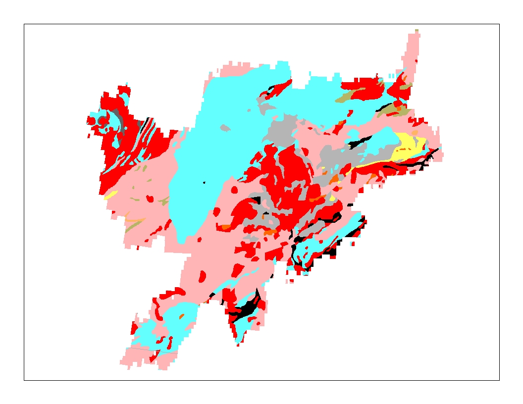
Bedrock geology of the Thelon River drainage basin in Northern Canada. The average bedrock age, weighted according to area of lithologic units, is 2.3 billion years. It is one of the oldest large river basins on Earth. Lithologic units are color coded: blue: marine sediments (33.5%), yellow: continental sediments (1.3%), tan: intercalated sediments and volcanics (1%), light gray: felsic volcanic rocks, dark gray: basic volcanic rocks (3.7%), orange: intermediate intrusive rocks (0.7%), red: felsic intrusive rocks (21.3%), pink: metamorphic rocks (32%). The 87Sr/86Sr isotope composition of dissolved strontium in the Thelon river is fairly radiogenic (about 0.718) and typical of runoff from old shield areas.