Science Highlights
New England time-series documents climate-driven shifts in phytoplankton bloom timing
New paper published in Science (Hunter-Cevera et al., 2016) documents climate-driven shifts in timing of coastal phytoplankton blooms on New England shelf recorded at the Martha's Vineyard Coastal Observatory. View e-Letter published by time-series scientists and members of OCB Ocean Time-series Committee.
Boknis Eck Time Series Station: Special Issue in Biogeosciences
The Boknis Eck Time Series Station is one of the oldest -still operated- time series sites worldwide. Monthly sampling at Boknis Eck began in April 1957. The site is located at the entrance of the Eckernfoerde Bay (54°31.2' N, 10°02.5' E) in the southwestern Baltic Sea. It has a water depth of 28 m with muddy sediments. Riverine inputs into the Eckernfoerde Bay are negligible and thus the overall hydrographic setting at BE is dominated by the regular inflow of North Sea water through the Kattegat and the Great Belt. Seasonal stratification occurs usually from mid-March until mid-September and causes pronounced hypoxia which sporadically become anoxic. The location of BE is ideal to study (i) a coastal ecosystem under the influence of pronounced changes of salinity and (ii) biogeochemical processes sensitive to changes of dissolved oxygen. A collection of seven articles presenting actual results from Boknis Eck are now available in a recently published special issue of the open access journal Biogeosciences: http://www.biogeosciences.net/special_issue116.html . The articles cover a wide range of various aspects of the biogeochemical and the ecological time series measurements at Boknis Eck including the nitrogen cycle in the sediments, hard bottom and benthic foraminiferal communities, exchange processes at the sediment/water interface, pelagic productivity, and the chemical composition of the sea surface nanolayer. A comprehensive overview of publications on Boknis Eck from the last five decades as well as additional information about on-going activities and facilities at Boknis Eck can be found under www.bokniseck.de.
CARIACO Scientific highlights published in the LOICZ Newsletter
A comprehensive overview of scientific achievements and insights from the CARIACO time-series was published in the most recent version of the Land-Ocean Interactions in the Coastal Zone (LOICZ) newsletter LOICZ In Print. LOICZ is a core project of the International Geosphere-Biosphere Programme (IGBP) and the International Human Dimensions Programme on Global Environmental Change (IHDP). Active since 1995, the CARIACO time-series is a partnership between Venezuela and the United States. Located on the continental shelf of Venezuela, measurements at this time-series site provide important insights into land-ocean interactions, as well as larger-scale oceanographic and atmospheric features and processes. CARIACO is an affiliated project of LOICZ.
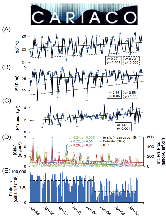
Figure Caption: Trends in (A) sea surface temperature (SST) and in SST annual minima (broken line), (B) mixed layer depth (MLD) and MLD annual maximum (broken line), (C) N* in the sq= 25.0-25.5 kg.m-3 isopycnal layer (~0-100 m), (D) [Chl-a] and integrated PP (0-100 m). r and p-values are shown within solid and broken line boxes or colored text for the corresponding trendline. (E) integrated diatom density (0-100 m) showing diatom abundance medians for 1996-2004 and 2005-2011.
The Future of Ocean Time-Series Research
The organizers of the 2010 OCB scoping workshop on biogeochemical ocean time-series recently published a paper that summarizes the outcomes and community recommendations from the workshop. The article provides a nice historical perspective of the scientific accomplishments and future directions of research at the Hawaii Ocean Time-series (HOT), the Bermuda Atlantic Time-series Study (BATS), and the CARIACO Ocean Time-Series (Church et al., In Press).
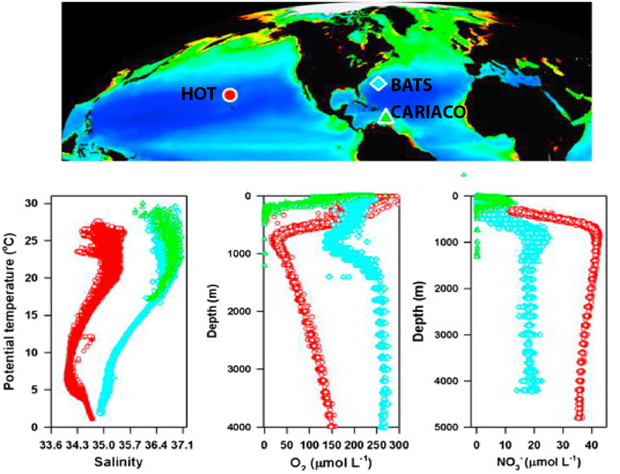
Figure caption: Study locations of HOT (red circle), BATS (blue diamond), and CARIACO (green triangle) superimposed over 6-year composite of satellite-derived near-surface ocean chlorophyll concentrations. Bottom panels depict temperature–salinity relationships, and vertical profiles of dissolved oxygen and nitrate+nitrite from the three time-series sites. Satellite data courtesy of NASA (modified from Church et al., In Press).
BIOS Scientists Mark 25 Years of Sargasso Sea Research
Bermuda, February 1, 2013 - Ali Hochberg (BIOS Communications & Education Coordinator)
Since October 1988, scientists have been sampling the deep ocean waters of the Sargasso Sea as part of the Bermuda Atlantic Time-series Study (BATS) project, with 2013 marking the program’s 25th year of continuous operation by the Bermuda Institute of Ocean Sciences (BIOS).
A recent paper published in the journal Deep Sea Research Part II: Topical Studies in Oceanography provides an overview of the project’s scientific findings under a team of scientists led by Dr. Nicholas Bates (BIOS), Dr. Rodney Johnson (BIOS) and Dr. Michael Lomas (Bigelow Laboratory).
The authors note that, “With 25 years of measurements for most chemical, physical, and biological water properties, we have moved beyond descriptions of seasonal and year-to-year variability” to addressing long-standing scientific questions about the Sargasso Sea, including:
- Why is there a discrepancy between the biological and geochemical estimates of carbon export production?
- What supports the seasonal drawdown of carbon dioxide in the absence of detectable nutrients?
- What are the sources of the elevated nitrate to phosphate ratio in the seasonal thermocline?
Recent BATS data helps shed light on these scientific questions and makes significant strides in improving scientists’ understanding of the processes and mechanisms that control biogeochemical cycles in the North Atlantic Ocean.


