Climate
 Climate change is one of the most pivotal issues facing us today; the consequences of which could result in decreased fresh water availability, food scarcity, wide spread flooding, and an increased damage from extreme weather events. In order to understand the magnitude of the current climate trends we must understand what factors contributes to the overall variability, and what climate conditions have been in the past. Only then will we be able to draw informed conclusions about what to expect in the future.
Our observational record is brief, and the high resolution satellite era is briefer still. The time scales that the Earth’s climate operates within may span many years to many thousands of years. We enhance our limited observation data by the use of proxy records which provide insight into conditions from the recent and deep pasts. Long term temperature oscillations and shifting weather patterns, changes in atmospheric circulation, drought, the frequency of extreme weather, pre-historic sea levels, can be deduced from the proxy data sets. By examination of the past we can develop a framework for which to evaluate the present climate change. Such paleo-records and modern observations can be used to direct and enhance modelling efforts that offer insight into how our climate may continue to evolve.
Storms
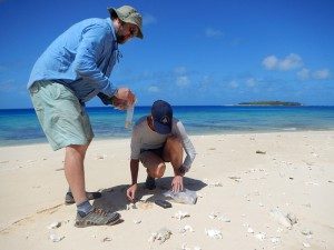
Extreme storms pose a significant threat to lives and resources in heavily populated coastal regions. However, because of the relative rarity of intense hurricanes (>Category 3) making landfall and the shortness of the instrumental record, little is known about past patterns of intense hurricane activity. In appropriate depositional settings, such as backbarrier marshes and tropical lagoons, a geologic record of hurricane strikes can be well preserved. In studying sediments from these environments, we aim to construct records of past intense storms and their impacts on coastal landforms, and understand how hurricane activity may be related to changes in regional and global climate over millennial timescales. Current work includes developing records of intense hurricane landfalls along the Atlantic coast of the U.S. and Canada, as well as in the Caribbean Sea and Japan.
Paleotempestology in the Atlantic
We adopt a multi-site/multi-environment approach to reconstruct past intense hurricane landfalls by targeting sites with different flooding thresholds (backbarrier marshes, coastal kettle ponds, blue-holes, etc) This strategy allows us to estimate the elevation and distribution of individual prehistoric storm surge events, overcoming potential difficulties associated with localized changes in sensitivity to storm surge. Applying these methods at sites from the Caribbean to Newfoundland allows us to construct a comprehensive picture of hurricane activity in the North Atlantic. This integrated approach has taken many years of field-work, but has produced great results not only in constructing hurricane records in individual locations but in the big-picture analysis of comparing sites. By including islands that hurricanes cross early in their track as well as the points where they make landfall and end this method can distinguish between changes in hurricane genesis and changes in hurricane track.
Typhoon Reconstructions from Southern Japan
On average, a third of all tropical cyclones in the world occur within the Northwest Pacific basin, yet very little is known about how typhoon activity in this region varies on timescales greater then a few decades. Locally nicknamed “Typhoon Ginza” after Tokyo’s most popular shopping district, Koshikijima comprises a group of small, remote islands in southeastern Japan that are frequently struck by typhoons. The coastline of these islands is relatively unique, flanked with deep lagoon systems that are episodically overwashed during intense tropical cyclone events. This makes Koshikijima an ideal setting for obtaining long-term typhoon records, which will help to improve our understanding of what has driven tropical cyclone variability for the North Pacific in recent geologic history.
Sea Level
Sea level change dictates the long-term evolution of coastal systems, ecologically and geologically. Furthermore, in the modern world coastal systems are home to a large segment of the world’s population. In order to more accurately project future changes in sea level and mitigate socio-economic impacts on human populations, we need to better understand the causes of sea-level change and how these changes may be linked to climate variability. Namely, we must distinguish between natural and human-induced climate and sea-level changes. To accomplish this, it is necessary to extend the relatively short instrumental record of sea level change (~120 years) with paleoclimate information deduced from sediments. The coastal group at WHOI has several projects aimed at quantifying the direction and rate of sea-level change and its influence on coastal evolution on a variety of temporal and spatial scales.
Marsh Community Dynamics
Salt-marsh communities are sensitive areas that respond dynamically to changes in sea level. Coastal sediments have the potential to preserve plant macrofossil evidence of past changes in marsh community-composition, thus providing insight into how sea level rise in historic times has affected the ecology of the marsh.
New England provides an ideal setting for such studies, where salt-marsh communities are linked to the magnitude, frequency and duration of tidal inundation. For example, from our sediment cores we are able to document recent migration of low-marsh cordgrass (Spartina alterniflora) into the high marsh. Isotopic dating indicates that the initiation of cordgrass migration occurred in the late 19th century and is coincident with a recent acceleration in the rate of sea-level rise. If current rates of sea-level rise continue or increase slightly over the next century, New England salt marshes will be dominated by cordgrass. If climate warming causes sea-level rise rates to increase significantly over the next century, these cordgrass marshes will likely drown, resulting in extensive losses of coastal wetlands.
Marsh Drowning
The recent expansion of water-logged pannes (potholes) in salt marshes throughout the northeastern U.S. is attributed to increased tidal flooding associated with accelerated rates of sea-level rise. In fact, the significant expansion and coalescing of pannes has been invoked as a mechanism leading to extensive salt marsh loss in some areas. However, very little work has examined the long-term evolution of pannes. Core samples obtained from non-panne areas of salt marshes from all over the northeastern U.S. show little evidence of past panne occurrence and may indicate that extensive panne development is a relatively recent phenomenon. Paleo-environmental reconstructions of modern pannes can help answer the following fundamental questions: 1) when did modern pannes develop? 2) are they changing in aerial extent? 3) if they are expanding or contracting what is the rate and direction of change? 3) has the rate and direction of expansion and/or contraction changed over time? and 4) is there a correlation between panne expansion and warming climate and increased rates of sea level rise? In the face of these ongoing and potential alterations we need to understand how the productivity of coastal wetlands may change, how changes in plant communities will impact migratory bird and other faunal populations, and how the loss of coastal wetlands will impact other coastal ecosystems.
Paleohydrology
The complex and multivariate nature of climate requires that analyses of past climate change consider not only temperature variations, but also changes in moisture balance. Sub-millennial-scale Holocene climate variation may be best characterized by hydrologic variability. ‘Spatial fingerprints’ of paleohydrologic change (e.g., regional contrasts in the direction and magnitude of moisture balance) may be studied in order to better understand how North Atlantic circulation patterns, the rapid collapse of the Laurentide Ice Sheet, and other factors have caused sub-orbital climate variability during the Holocene.
Centennial to Millennial-Scale Change in New England Lakes
Small lakes without surface inlets or outlets can provide a record of past water table fluctuations (lake level) within their sediment record. Using geophysical sub-bottom imaging tools (e.g. ground penetrating radar and Chirp sonar) we are mapping the sedimentary record of lakes throughout the northeastern U.S. Targeted coring allows for the recovery of key stratigraphic intervals for sedimentological analysis, dating, and interpretation. Future work includes extending this analysis to lakes across eastern North America and Europe. Analysis of sites across the east-west moisture-balance gradient of North America and Europe will allow the examination of the full character and impacts of late-Quaternary climate variation on a continental spatial scale.
Annual to Decadal-Scale Records of Hydrologic Change
Understanding the causes of short-term climate variability is critically important if we are to be able to predict future changes and possibly mitigate their impacts; it is environmental change on these timescales that may pose the greatest challenge to society. To study climate on the annual and sub-decadal level, we are developing records using tree rings and varved sediments in New England. Many cedar bogs in the previously glaciated northeast U.S. formed in the early Holocene, and the wood preserved within these sediments contains an as of yet unexploited annual record of climatic variability. Preliminary oxygen isotope data from fossil cedars show significant sub-decadal variability likely related to changes in hydrologic regime. Further development of these records will provide an unprecedented description of paleoclimatic variability for the northeastern United States. Similarly, sediments recently recovered from Pout Pond, NH contain varves extending back ~14,000 years. Coupling isotopic and other sedimentological proxy records of environmental change from Pout Pond with cedar tree ring records will provide critical insight into the nature of late Quaternary hydrological variability in New England at an unprecedented temporal scale.
Abrupt Climate Change
Changes on the terrestrial landscape can cause alterations of the climate system. For example, glacial meltwater pulses into the North Atlantic Ocean are often postulated to have altered thermohaline circulation by shutting down North Atlantic Deep Water (NADW) formation and initiating abrupt climate-cooling events like the Younger Dryas (YD) and the “8.2 ka event”. In order to understand the influence of glacial meltwater pulses on millennial-scale climate change, it is critical to constrain the timing, magnitude, and location of meltwater release.
To address this issue, we are currently analyzing the terrestrial and near-shore evidence of meltwater drainage in eastern North America. New evidence indicates that the Hudson Valley was the conduit for catastrophic drainage of meltwater (>1012 m3) from Glacial Lake Iroquois (and other large glacial lakes at the southern margin of the Laurentide Ice Sheet) between 13.1 and 13.5 ka. The timing of this catastrophic draining event down the Hudson Valley is consistent with the onset of the Inter-Allerod cool period, possibly indicating a direct link between meltwater flux through the Hudson Valley and centennial to millennial-scale changes in ocean circulation and climate.
Extreme Fluvial Floods
Sediments deposited in settings with continuous accumulation, such as floodplain lakes or prodeltas, offer records of extreme hydrologic variability at potentially high temporal resolution. Recently recovered cores from the Danube floodplain and delta reveal a record of large flood events over the last 1000 years. These sediments will allow us to quantify and reconstruct the evolution of the Danube delta in the late Holocene, and explore links between shoreline evolution, discharge, sea-level variability, and climate.


")