The Project Approach
 Our approach is centered on collaborative engagement between end users and project team members. This started by engaging a core group of end users and learning about knowledge gaps in management approaches and science needs. These conversations laid the groundwork for better understanding the types of outputs, data products, and decision support tools end users need to more effectively manage marsh hydrology.
Collaborative approach
End users are integrated into every aspect of this project to ensure that the science and tools produced can truly inform management decisions. We are using a collaborative learning approach, which ensures that end users are not just recipients of information but rather bring their knowledge and expertise to bear. This both helps end users realize the value of their input to the research process and encourages researchers and end users to embrace the importance of working together. This collaborative process will ensure (1) that the decision support tools developed meet management needs, (2) end users develop a better understanding of impacts of hydrologic alteration and have science-based information to guide management, (3) end users have confidence in applying the model to their management scenarios.
Research approach
Our core research questions are: (1) How are metrics of marsh ecosystem services and sustainability affected by ditch density and tidal range?; and (2) How do hydrologic management approaches interact with sea level and tide range to affect marsh sustainability? Results from our field, lab, and modeling research will be synthesized to create decision support tools that allow end users to assess the tradeoffs of hydrologic management decisions.
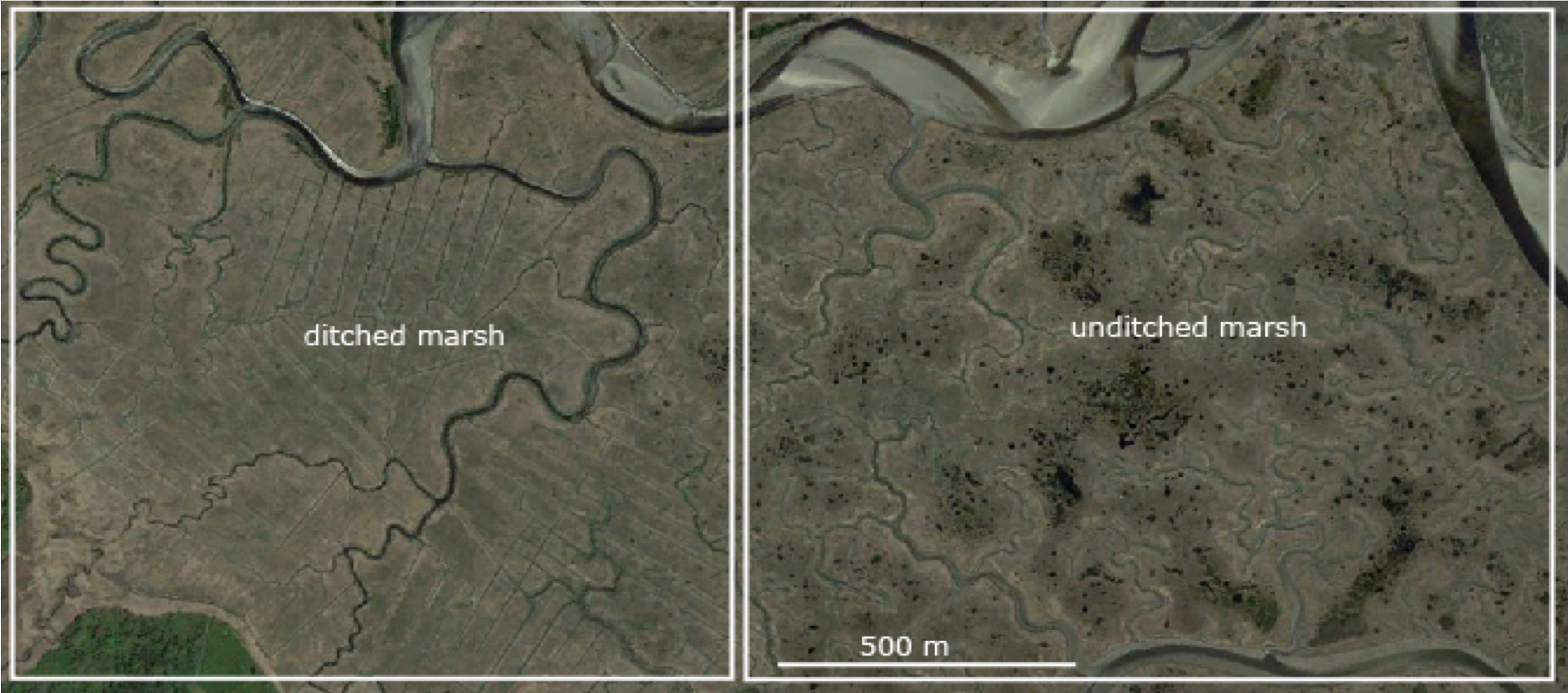
Study sites
Our main study sites are the Great Barnstable Marsh (GBM) and WBNERR’s Sage Lot Pond (SLP) marsh. GBM is a macrotidal system with an extensive high marsh platform that is connected to Cape Cod Bay by a series of tidal channels. This is an ideal study system because 60% of the marsh was ditched in the 1930s, leaving ~ 40% un-ditched. Ditched and un-ditched areas are grouped into large swaths that are adjacent to one another, which eliminates potential confounding effects of different geographic and geomorphic settings. SLP is a microtidal marsh where pools and ditches are co-located. SLP was also a focal point of an earlier NSC project, Bringing Wetlands to Market, and is part of the NERRS salt marsh sentinel site program. Comparisons between GBM and SLP will be important in understanding how tide range interacts with ditch density and management decisions to affect marsh properties and ecosystem services. To address our research questions, we are collecting a range of data on marsh elevation, plant communities, soil properties, and vertical accretion rates. These data will be integrated into the Marsh 2D Model, which will provide decision support for end users.