Novel Applications of ICESat-2: Coastal turbidity and suspended particulate matter
ICESat-2 is a NASA satellite that launched in 2018 carrying the Advanced Topographic Laser Altimeter System (ATLAS) instrument. It was designed to measure ice sheet surface and global vegetation elevations. ATLAS is a space-based lidar sensor that uses six green laser beams (three pairs of weak/strong beams) to transmit photons, some of which are reflected from Earth’s surface.
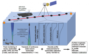
This project uses in situ observations (taking data in real time) to pair with satellite records from ICESat-2 to understand how satellite lidar can help to better quantify sediment transport.
Photon returns are sometimes detectable in subsurface waters up to 40 m deep, depending on water clarity and other environmental conditions. Several studies have assessed the utility of ATLAS data for measuring coastal bathymetry. An additional interesting product is the photon return from the water column itself; these returns are attenuated through both absorption and scattering (e.g., off of sediment particles), much in the same way that natural sunlight or constituents like photosynthetically active radiation (PAR) are attenuated.
We are conducting a study to evaluate how well ATLAS photon returns can represent suspended-sediment concentrations in surface waters and suspended-sediment inventories throughout the water column. This project is led by Dr. Emily Eidam at Oregon State University, along with collaborators Dr. Kelsey Bisson at OSU and Dr. Chao Wang at UNC.