Marine Gravimetry
Marine gravity measurements allow scientists to better understand the Earth's crust by providing quantitative constraints on the structure of the crust and, in combination with other co-registered data sets and forward models, improve our ability to interpret the geological processes occurring within oceanic crust. As an engineer and robotist, I pursue new methods for obtaining these measurements from underwater robots. This work requires research in navigation, control, and sensing. In addition, I support the collection of gravity data on research vessels throughout the world.
AUV Gravimetry
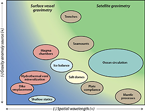
While these measurements are routinely obtained from surface vessels (including through an NSF funded sea-surface marine gravity program I run), the resolution and spatially density is significantly improved when measurements are obtained from underwater vehicles operating near the seafloor. Near seafloor measurements have been previously obtained with piloted submarines and towed sleds; however, their high cost precludes routine acquisition of these measurements. Furthermore, these vehicles lack the precision control and navigation necessary for minimizing vehicle motion and for separating the accelerations of the vehicle from the gravity signals being measured. I have been researching precision navigation methods that would enable AUVs to obtain measurements superior to those previously obtained and at a lower cost. Kinsey et al., 2013 shows that nonlinear dynamic model-based state estimators provide superior estimates of the vehicle’s vertical accelerations than methods used in previous underway submarine gravity surveys, thereby providing more precise measurements and allowing us to detect smaller features in the shallow oceanic crust. Additional research has focused on new trajectory planners for AUV gravity surveys that minimize AUV motion in order to obtain better gravity measurements (Izraelevitz 2010) and the investigation of a new class of smaller and less power consumptive gravimeters. This sensor research exploits a new type of accelerometer that when combined with highly accurate attitude measurements from an INS eliminates the electronics and leveling table required for traditional gravimeters. The first generation system was deployed on the Sentry AUV in 2011 and served as the basis for a new, second-generation AUV gravimeter that is currently being evaluated in the laboratory.
Sea Surface Gravimetry
In addition to researching new methods for measuring gravity from AUVs, I also oversee the Potential Feld Pools (PFPE), an NSF funded facility that supports and maintains the U.S. academic community's fleet of gravimeters. These gravimeters are deployed on 10 ships that travel all over the world including the Arctic and Antarctic. Read more about PFPE here.
