SPURS-1
Microstructure and Mixing Measurements During SPURS
The Salinity Processes in the Upper Ocean Regional Study (SPURS) Program was designed to examine those processes affecting the near-surface salinity. It was proposed as a 2-phase effort, with the first phase focusing on the high salinity, high evaporation maximum of the North Atlantic during 2012 – 2013. The second phase, SPURS-2, is scheduled to take place in 2016 - 2017 in the low surface salinity, heavy rainfall of the intertropical convergence zone region of the eastern tropical Pacific.
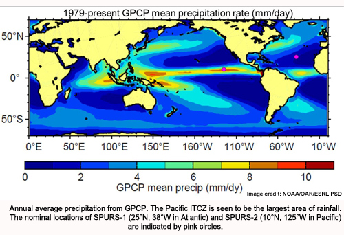
The low salinities in the area are driven by some of the largest rainfall rates on the planet. Research effort is actively addressing the essential role of the ocean in the global water cycle. A series of cruises is exploring the salinity maximum region in the Atlantic Ocean using a plethora of oceanographic equipment and technology, including salinity-sensing satellites. Researchers are studying salinity changes that span thousands of miles simultaneously with those happening in one centimeter of water. SPURS is also providing much-needed data for computer models to improve our basic understanding of the water cycle over the oceans and its ties to climate.
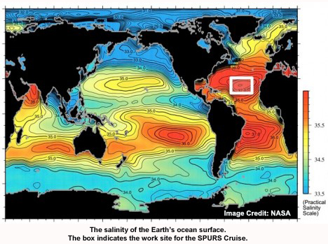 The overall goal of the program is to better understand the role of the ocean in the global water cycle. The destination for this cruise is the saltiest spot in the Atlantic ocean, where scientists will spend several weeks collecting data on the processes that effect salinity in an effort to better understand the effect these processes have on the global water cycle.
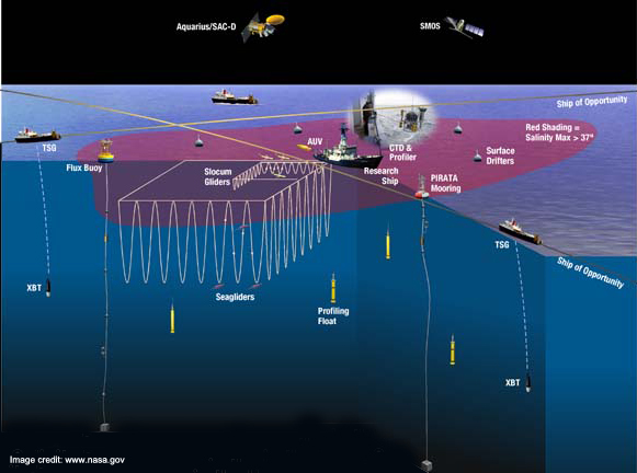
Many different instruments will be used to collect data at the work site. These include CTDs, LADCPs, gliders, and floats, just to name a few. Specifically, Woods Hole Oceanographic Institution’s Mixing, Measuring, and Modeling Group will be deploying a Deep Ocean Profiler and two Slocum Gliders. Additionally, both of the gliders will be carrying MicroRiders, which are small instrument packages for turbulence microstructure measurements.
The deep ocean profiler – a Rockland Scientific VMP-5500 – is lowered into the water and released. In its pressure housing, it carries batteries and electronics. The data collected by the external sensors is recorded to a disk drive inside the instrument. The steel ballast weights it carries cause it to sink to a pre-set depth. Upon reaching the pre-set depth, a trigger mechanism is fired, causing the weights to be released, and the instrument to float back to the surface. The instrument is then brought back on-board, the data is downloaded from the instrument, and preparation for the next deployment begins. Although the instrument is capable of profiling to 5500 m, most of the profiles on this cruise are being done to a depth of 1200 m, which take about one hour from the time the instrument is deployed until it re-surfaces.
Longer duration measurements are performed by the shallow water undersea gliders (Teledyne-Webb Slocum Gliders), each carrying a Rockland Scientific MicroRider. The MicroRider is similar to the VMP, but is much smaller in size since it does not carry its own batteries; it draws power from the glider. The glider does not utilize direct propulsion, instead changing it’s buoyancy to move up and down in the water column and using wings to translate this motion from vertical to horizontal. This low power design means microstructure data can be collected continuously over a time period covering weeks, even months, with minimal manpower requirements. One glider is covering the upper 70 m of the water column while stationed in a small area close to the WHOI mooring, while the other glider is covering the upper 200 m of the water column while doing continuous transits between the WHOI mooring and PMEL-N mooring.
Funding Agencies
The National Science Foundation, National Aeronautics and Space Administration, and the National Oceanic and Atmospheric Administration funded this research.
Partners/Collaborators
This is a joint project with the University of Washington, University of North Carolina Wilmington, Remote Sending Solutions, Inc., Lamont-Doherty Observatory - Columbia University, NASA-JPL, Scripps Institution of Oceanography, NOAA Atlantic Oceanographic and Meteorological Laboratory, NOAA Pacific Marine Environmental Laboratory, Institut de Ciències del Mar - CSIC, L'Ocean - University of Paris, and the National University of Ireland - Galway.