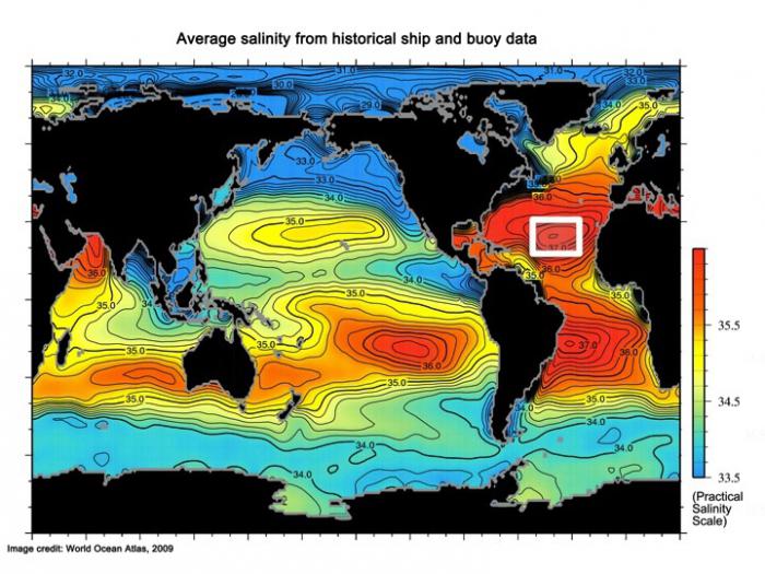
Upper Ocean Salinity Structure Variability
Satellite measurements of the sea surface salinity (SSS) data from ESA’s Soil Moisture and Ocean Salinity (SMOS) satellite and NASA’s Aquarius satellite has the potential to transform our understanding of the number of scales of the Earth’s Water Cycle. To address the needs of the SSS community, a concerted data analysis approach combined with ocean modeling focused on understanding variability in the upper few meters of the ocean surface will provide insights. Our goal is to use the unprecedented coverage of SSS data offered by Aquarius in tandem with near-surface salinity measurements available from SPURS, in situ buoys and the Argo float program, and modeling analyses to better characterize and parameterize the surface salinity stratification with respect to atmospheric variability.
To accomplish this, we are doing the following:
- Characterize the upper ocean salinity variability and its relationship to atmospheric forcing by analysis of data available from the Salinity Processes in the Upper Ocean Regional Study (SPURS) and in situ buoys with both sea surface and near-surface temperature and salinity measurements.
- One-dimensional (and in the case of SPURS three-dimensional) ocean models will be used to provide further understanding of the sensitivities of the upper ocean salinity stratification to the surface freshwater, heat, and momentum fluxes.
- Create a co-located set of satellite SSS points with Argo and other in situ data sets.
- As part of this analysis we will enhance the WHOI Argo float system by analyzing the raw 1 Hz (10 cm sampling) data available from some current and future floats, as well as programming a small group of floats under certain conditions to produce a high temporal resolution (3 hourly) set of profiles to investigate the bias effects of the diurnal cycle on the satellite measurements.
- We will use these matched observations to explore the representativeness of Aquarius and SMOS observations with that of the salinities at depth. Using satellite-derived weather regimes we will explore how surface and deeper salinities are related under specific weather/surface forcing regimes, and to what extent this is comparable to the in situ data/modeling analysis.
- Parameterize the upper ocean salinity stratification based on the observational/model results, and use this parameterization to provide information on skin salinity variability affecting the Aquarius-Argo matchups.
Funding Agencies
The National Aeronautics and Space Administration funded this research.