Modeling the spatial dynamics of marsh ponds in New England salt marshes
Check out the Geomorphology paper (Mariotti et al., 2020) that has been published based on Great Barnstable Marsh, MA model results!
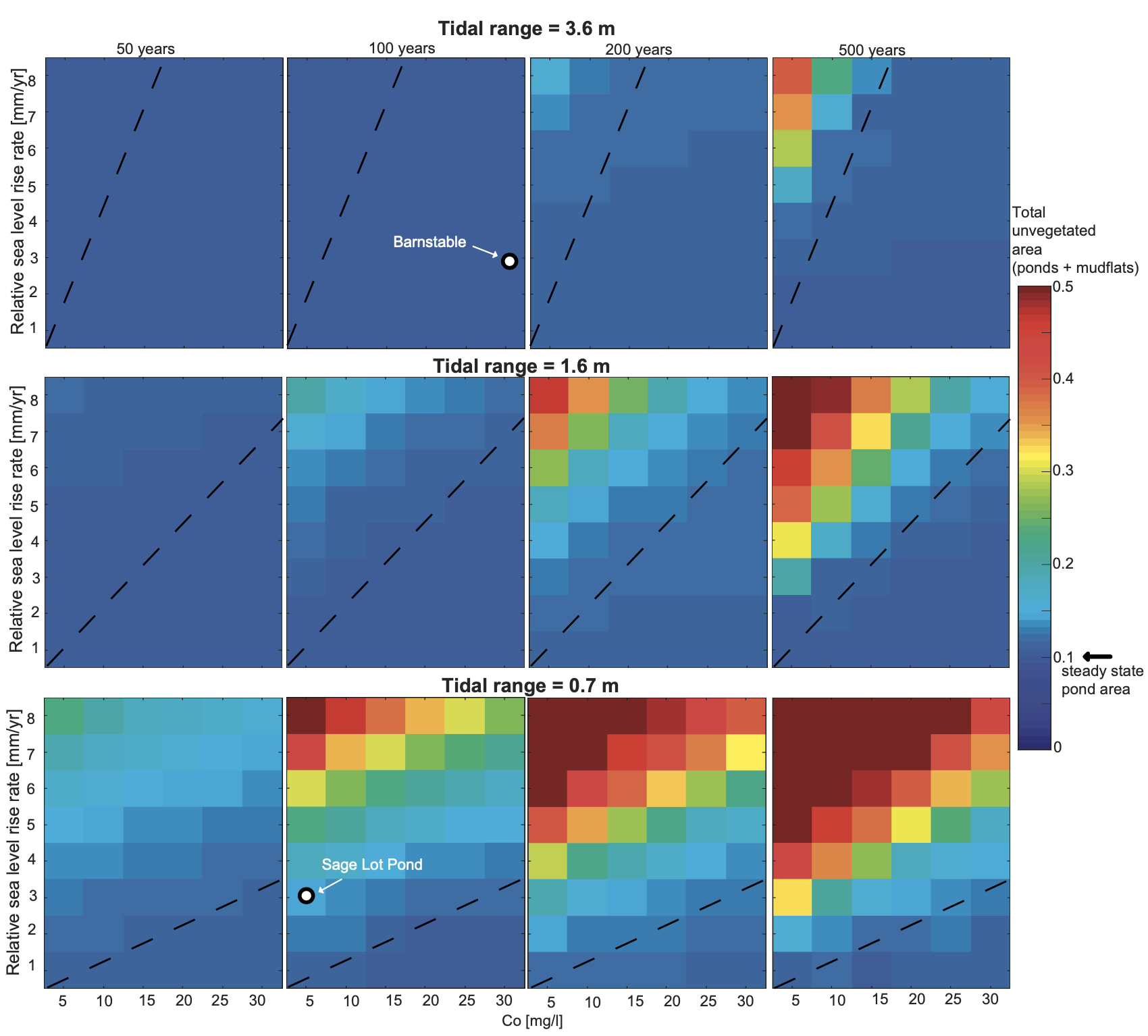
Abstract:
Ponds are common features on salt marshes, yet it is unclear how they affect large-scale marsh evolution. We developed a spatially explicit model that combines cellular automata for pond formation, expansion, and drainage, and partial differential equations for elevation dynamics. We use the mesotidal Barnstable marsh (MA, USA) as a case study, for which we measured pond expansion rate by remote sensing analysis over a 41-year time span. We estimated pond formation rate by comparing observed and modeled pond size distribution, and predicted pond deepening by comparing modeled and measured pond depth. The Barnstable marsh is currently in the pond recovery regime, i.e.,every pond revegetates and recovers the necessary elevation to support plant growth after re-connecting to the channel network. This pond dynamic creates an equivalent (i.e.,spatially and temporally averaged over the whole marsh) 0.5–2 mm/yr elevation loss that needs to be supplemented by excess vertical accretion. We explore how the pond regime would change with decreased sediment supply and increased relative sea-level rise (RSLR) rate, focusing on the case in which the vegetated marsh keeps pace with RSLR. When the RSLR rate remains below the minimum unvegetated deposition rate, the pond dynamics is nearly unaltered and ponds always occupy ~10% of the marsh area. However, when RSLR rate exceeds this threshold, the ponds in the marsh interior – which receive the least amount of suspended sediment – do not recover after drainage. These ponds transition to mudflats and permanently occupy up to 30% of the marsh area depending on RSLR rate. For marshes with a small tidal range, such as the microtidal Sage Lot Pond marsh on the opposite side of the peninsula from Barnstable marsh, high RSLR rates could bring every portion of the marsh into the pond runaway regime, with the whole marsh eventually converting into mudflats. In this regime, the existing marsh would disappear within centuries to millennia depending on the RSLR rate. Because of the spatial and temporal components of marsh evolution, a single RSLR threshold value applied across the entire marsh landscape provides a limited description of the marsh vulnerability to RSLR.