Technical Capabilities
- Autonomous Underwater Vehicles (AUVs)
- Remote Operated Vehicles (ROVs)
- Autonomous Aerial Vehicles (AAVs)
- Sensor Development and Integration
- Adaptive Sampling; Software Development, Backseat Autonomy (ROS)
See below for a snapshot of current capabilities in play:
Autonomous Underwater Vehicles
Our lab currently innovates and operates the REMUS class AUVs and MBARI LRAUVs. We build, invent, operate and everything in between for ocean platforms. We also have access to surface vehicles and ROV’s at WHOI. Additionally, our lab owns and operates Blue Robotics ROVs for surveys and AUV recoveries as well as aerial drones.
Our vehicles can operate from hours to weeks depending on payloads and mission specifications. Some current applications and capabilities are outlined below.
We also have dozens of sensing capabilities for biological, chemical and physical oceanographic sampling. Some of these capabilities are outlined in this document. If you don’t see what you're looking for, please give us a call or email.

Figure 1. Polaris LRAUV is picked up by a USCG Jayhawk in Woods Hole in April 2021. The vehicle was successfully deployed into Buzzards Bay where it ran a mission before being recovered by a small boat.
What we have and in current development:
- Rapid Response – Oil spills, shipwrecks search/surveys, weather, environmental anomalies
- Reliability (System failure recoveries)
- Accurate navigation (LBL, USBL, INS, particle filtering, machine learning/terrain following, no surfacing)
- Long-range (from hours/days to weeks/months)
- Data Relay (no surfacing)- comms from AUV to buoy to shore/surface iridium
- Data Visualization (quick decision making)
- Use AUVs to predict/map ice- ADCP currents
- Launch & Recovery (tiny boats, helicopters/C-130’s, icebreakers, ice holes, and shipless from shore)
- Sidescan and multibeam mapping
- Front tracking (temp, chlorophyll, salinity, etc.)
- Water samples
- Over-the-horizon - send data anywhere in near real time
- Video and still pictures, stereoscopic imagery
- Holographic imagery
- 3D tracking and imaging of randomly moving targets (and megafauna)
- Plankton imaging
- Dynamic Docking (extend duration or park until needed)
- Windfarm surveys
- Aquaculture and benthic surveys
Highlighted Capabilities (Docking, Oil spill response, water column mapping, shipwreck response, under-ice capable, multi-mission capabilities):
Docking
Our AUVs home to our acoustic gateway buoys using an Ultra-Short-BaseLine (USBL) array. Aided by long “whiskers” that extend from the nose shell for line capture, it then uses the Dynamic Docking Module (DDM) to hook and latch onto the buoy anchor line. LRAUV can remain docked on the buoy anchor line conserving energy while awaiting new missions or recovery. This capability can extend the duration of which the AUV is deployed by allowing the robot to park for periods of time in a low power mode. By sending commands acoustically through the buoy micromodem, the AUVs can wake up to ‘sense’ or ‘listen’, as well as undock to run a new mission all while staying underwater or even under ice.
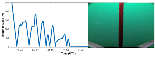
Figure 2. The plot of the vehicle's acoustic ranges to the dock show it making a few passes before finally docking. When in range of the dock the vehicle activates its go pro camera, capturing footage of its whiskers and the mooring line as it docks.
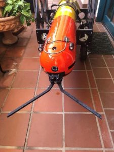
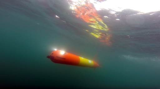
Figure 3. Pictured here is the MBARI 300-meter long-range core AUV outfitted with WHOI payloads for docking. Scibotics lab uses LRAUV+ extensively, often in collaboration with MBARI for science applications in open ocean or under-ice.
Oil-Spill and Water Column Mapping
Our AUVs currently use the Wetlabs SeaOwl UV-A sensor to detect dissolved petroleum hydrocarbons in the water using optical backscatter. In addition to using FDOM as an indicator of dissolved hydrocarbons, the improved LRAUV+ system has enhanced algorithms for detecting and mapping/following fronts for temperature, salinity and chlorophyll.
The baseline science sensor payload typically contains:
- Seabird glider payload CTD
- Seabird Dissolved Oxygen
- Licor PAR
- Wetlabs SeaOWL Ecopuck
- RDI 600 kHz ADCP Pathfinder in an up/down or down only configuration
- Backup Benthos Transponder
- Avalanche beacon (under-ice applications)
- LBL for navigation and communication
- Micromodem for communications and navigation
- Backseat autonomy (ROS)
- Argos Telonics backup communications
- Iridium/Cellular/Wi-Fi
Additional payloads/capabilities currently available (some testing/R&D may be needed to enhance capabilities to a particular application or AUV):
- Seascan holographic camera system
- 6-12 liter water sampler
- eDNA
- 150 kHz / 900 kHz sidescan sonar
- Norbit WBMS multibeam
- Soundtraps for measuring soundscape (LF and HF)
- Ixblue C3 inertial navigation
- Aandera Oxygen Optode 4831F
- ISIIS Plankton Imager
- WHOI DUSBL/homing
- WHOI Docking nose
- Stereoscopic imaging
- HD video
- LED lighting (torches and strobes)
- pH
- Turbidity
- Chelsea UviLux
- EK-80 acoustics
Many more payloads have been integrated and if we have not done it yet, we can! Please inquire within.
AUVs can be used for broadscale and finescale surveys and are typically utilized to work in groups to both cover more ground and different payloads, saving time.

Figure 4. LRAUV can be used as a broadscale survey vehicle saving time and money for other response assets. Here LRAUV is identifying all the oil seeps off the coast of Santa Barbara and relaying high concentrations of oil to a USCG vessel in the area as well as other sampling systems.
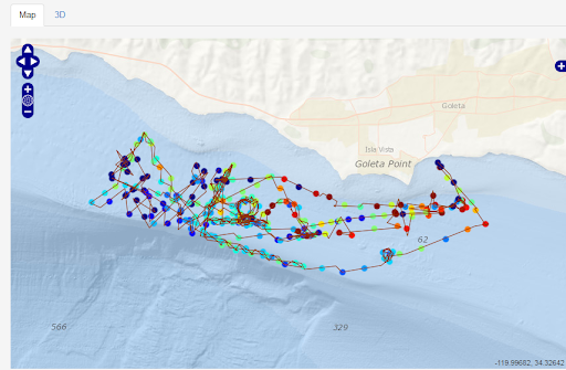
Figure 5. Additionally, LRAUV can detect and relay hotspots based on a predetermined threshold. It can then go back and conduct a fine-scale survey and relay data back to shore.
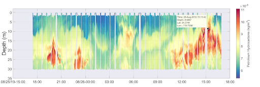
Figure 6. real-time plot of hot spots revealed from the SeaOWL sensor as seen on the lrauv.whoi.edu or MBARI online command control known as the ‘DASH’
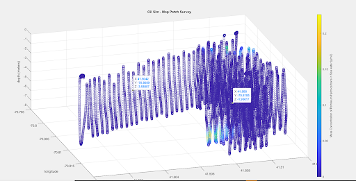
Figure 7. Water column mapping example data collected by LRAUV+.
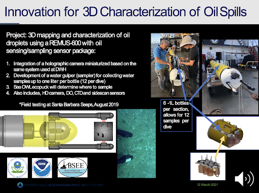
Figure 8. Holographic imagery and water sampling systems can be used in conjunction with each other and used on multiple platforms for oil, gas, plankton and other applications.
Shipwreck Response
A realistic tale:
Polaris was launched in the winter of 2022 from a Woods Hole Coast Guard chase boat and transited out to the site of Wreck 1487 nearly 80 miles from Woods Hole in a coordinated response effort with NOAA, WHOI, MBARI and USCG to map a leaking historic shipwreck.
Informed by incoming satellite data, Polaris ran a search pattern Northeast of the wreck site, sending oil data back to shore.
The LRAUV, “Polaris'' will travel to a known shipwreck labeled “Wreck1487”, approximately 70nm south of Nantucket, to test the sensitivity of an optical sensor and then see how well WHOI and MBARI’s adaptive mission survey can sniff out and map out an oil plume. The frequently (potentially constantly) leaking wreck will hopefully serve as a real-world proxy. Data will be collected from the following sensors:
- Up/down 1200 kHz ADCP (RDI)
- SeaOWL Wetlabs ecopuck
- Seabird glider payload CTD with embedded dissolved oxygen probe
- Licor PAR, photosynthetic artificial radiation
More specifically, data also includes and is gathered in the following manner:
- SeaOWL UV-A – CHL, FDOM, and Optical backscatter (OBS)
- CTD – Conductivity, Water Temp, and Depth
- DO Optode – DO Concentration and DO Saturation
- Merged data streams calibrated to common sampling rate of 1/second
- All sensor data retrieved as a .csv file (lat/lon/depth)
- AUV Fluorometry products
- OBS as a function of FDOM, 3D OBS/FDOM, 3D data model
- Data transfer: Wifi when surfaced, memory stick
- Processing time: Merged data stream ~15 minutes
NOAA has coordinated and provided background information to WHOI to help the group prepare for and plan their mission. NESDIS has shared satellite imagery from the leaking source, which was also analyzed through ERMA to identify a likely location for the wreck. ORR has shared RULET background information, ocean current information, and helped with coordination between WHOI and USCG Sector Southeastern New England. The USCG will be following the mission and studying the outcomes. NOAA’s Ocean Prediction Center is providing detailed specific on-site offshore weather forecasts for the area.
The mission is planned to commence on the morning of Jan 20. It is likely that the in-water transit time for the LRAUV to arrive on site will be approximately 3 days. Then the LRAUV will stay on site for 7-10 days before returning to land.
Daily operational briefs including staff from NOAA ORR and USCG are scheduled for the duration of the mission. Information and data gathered during the mission will be displayed in ERMA and updates will be provided in ResponseLink.
While surveying the leaky wreck, a Nor'easter hit the area. Instead of an emergency recovery, the LRAUV team shifted the mission to survey storm impacts and collect surface and undersea data before, during and after the storm for physical oceanographers at WHOI. The long-range capable platform enables multi-mission capabilities not possible in other AUVs and can operate in intense weather events.
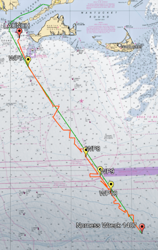
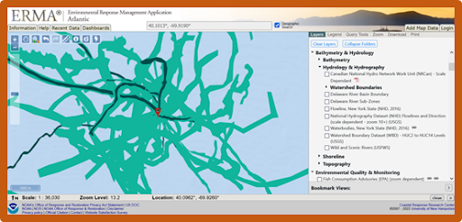
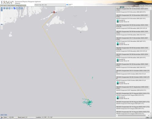
Figure 9, 10, 11. The transect line above on the chart shows Polaris LRAUV+ over-the-horizon mission track out to wreck 1487 on the shelfbreak. During this mission a Nor'easter hit the area and Polaris was able to stay out and collect storm data for scientists at WHOI. The figures on the right show fuel slicks on the surface captured by satellite near the wreck site.
Under-ice capability
LRAUV+ can be outfitted with onboard intelligence that allows it to swim and transmit data to shore without surfacing by using its buoy system and docking capabilities. The vehicle can also park at the buoy and await recovery if the weather is too rough. In anticipation of a worst-case scenario, LRAUV is outfitted with backup communications beacons and a strobe in case it becomes stuck or lost under ice. Our team also has a recovery ROV to assist if needed. We’ve operated in Antarctica, Greenland, Alaska and several other ice camps throughout New England with great success.

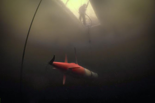


Figure 12-15. Pictures above are from LRAUV Polaris's under-ice mission in Bog Lake, Maine in February 2020. This was our first LRAUV under-ice mission where we successfully navigated to an ice hole and parked overnight.
Additionally, we have small portable 100-meter rated AUVs for open ocean and under-ice surveys.
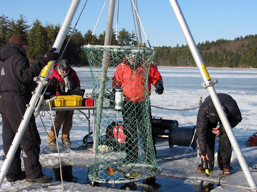
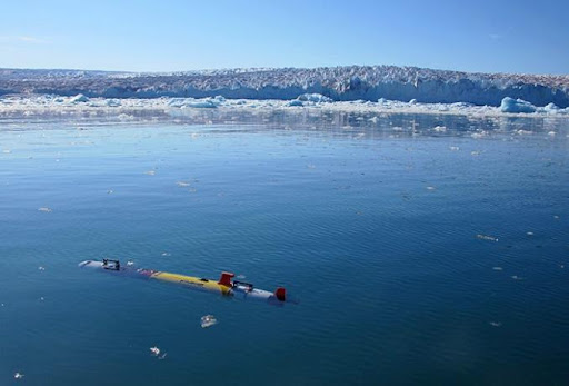
Figure 16-17. Pictures above show our team and 100-meter AUV being tested for the Arctic (in New Hampshire, 2010, (left) and operating off of a calving glacier in Greenland, 2012 (right).
Example multi-mission capabilities:
- Seafloor mapping
- Bathymetric charts
- Shipwreck search/map/classify
- Under-ice and glacier mapping
- Under-ice and in water oil/gas detection
- Soundscape measurements
- Marine protected species detection
- Military applications and port security
- Harmful Algal Blooms
- eDNA
- Front tracking
- Image and sonar surveys
- Benthic Surveys
- Aquaculture and Wind Farm surveys
- Grid and yo-yo survey modes
Example LRAUV+ Configurations:
LRAUV+ vehicles with four mission specific nose configurations:
- Open water science standard sensors, tall antenna, Chelsea UV, Soundscape
- LR under-ice with Whiskerbox, DUSBL, short antenna, Chelsea UV, Avi-beacon with room for camera, 900 Hz A-Nav
- Under-ice mapping, Whiskerbox, DUSBL, Multibeam, INS, short antenna, 900 Hz A-Nav, Avi Beacon
- Seafloor mapping, Multibeam, INS, tall antenna, soundscape
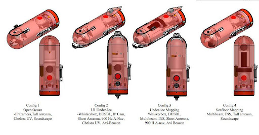
Figure 18. Above are four examples of in house LRAUV+ payloads that are currently available. We aim to be modular so we can move sensors around in payloads and between different vehicles.
Long Duration:
The LRAUV’s are small, about 30 cm (12 inches) in diameter, and easy to handle. Deployments range from a few days to over three weeks, and are unattended by ships. The longest-range mission to date was over 1800 km at a speed of 1 meter/second (m/s). In that deployment out and back from Moss Landing, California, the vehicle operated as far as 500km from shore independent of a ship. Ranges two to three times as great can be achieved by operating at a speed of 0.5 m/s with minimal sensors. Over-the-horizon missions are becoming standard with six occurring unattended by ships from Woods Hole now occurring since 2020 with the newest LRAUV+ vehicles.
Endurance can be maximized by using the buoyancy engine, which is a shifting internal weight, to trim to neutral buoyancy and drift at zero thrust with minimal sensors. The vehicle is typically shore-launched and recovered, using a small boat to tow the vehicle between the harbor entrance and a boat launch ramp. It can also be transported by helicopter to remote areas.
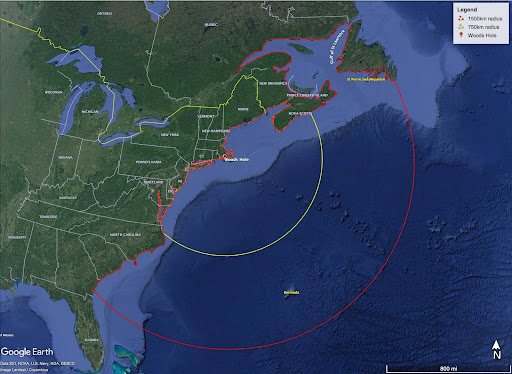
Figure 19. This map shows LRAUVs achievable maximum ranges with secondary batteries. Ranges 2-3 times that are possible with primary batteries.
Communication Capabilities:
LRAUV receives commands and sends telemetry data back to shore periodically when surfacing via Iridium satellite comms or cellular network (when available).
Limited bandwidth communication is possible while underwater, using the micromodem to acoustically transmit to the gateway buoys, and then the buoys to shore via Iridium.
Available communications systems:
- Iridium SBD messaging and emergency communications
- Local Wi-Fi
- GPS
- Argos RF
- Acoustic communications
- WHOI micromodem
- Buoy systems
- LBL
- USBL
- Benthos emergency transponder
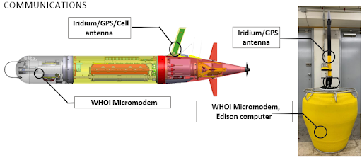
Figure 20. LRAUV communications diagram
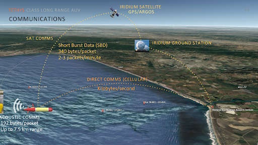
Figure 21. LRAUV communication assets overview.
Facilities at WHOI
The Scibotics Lab operates from the Village (dock) and Quissett Campuses with a new Center for Innovation housing the lab’s technology including a Maker Space, machine shop and several fresh and saltwater test tanks.
- Facilities: Scibotics lab operates facilities for fabrication, testing, logistics (on-ice support) and platforms such as AUVs and ROVs
- Service for-Hire: Operators, Engineers and AUV’s are available for hire for the Navy and commercial, non-profit sectors
- Hardware Builds: Scibotics has a history of replicating systems and training end users
- We own and operate vessels for operations and testing including the Scibotics R/V Maria Mitchell, a 7 meter RHIB.
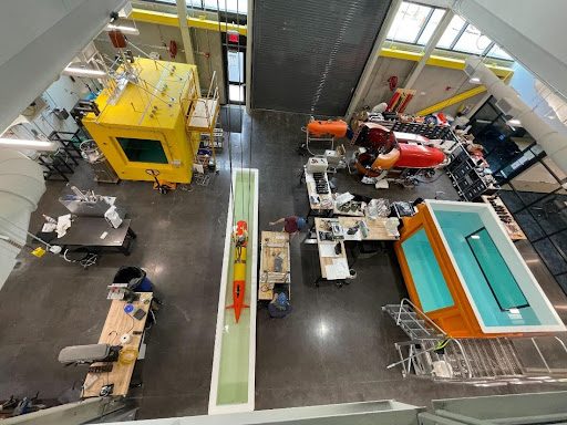
Figure 22. The WHOI Scibotics team leveraged WHOI’s Innovation Center to build, integrate and test sensors and Stella LRAUV+ with lots of MBARI synergistic collaboration. A brand new 1800 square foot lab is being built to accommodate Scibotics growth in the new innovation center.
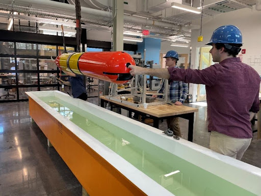
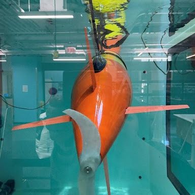
Figure 23 and 24. LRAUV+ being tested for the first time in water at the new innovation center at WHOI.
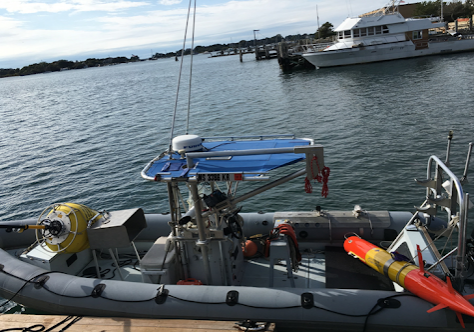
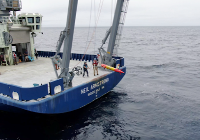
Figure 25. Seen on the right is the Scibotics R/V Maria Mitchell. Figure 26. Polaris LRAUV+ is being deployed from the R/V Armstrong in the right photo.
3D tracking and filming with ‘OceanEye’ (SharkCam, TurtleCam)
At Scibotics, we have the world’s only underwater robot that can track, film and collect 3D fine-scale resolution of megafauna including sharks, whales, seals, turtles and more.
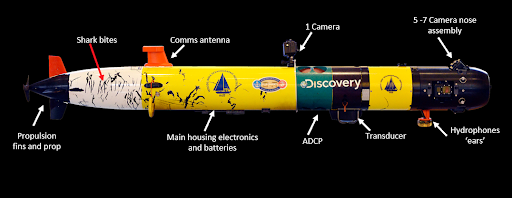
Figure 27. Our team developed the famous ‘SharkCam’ and ‘TurtleCam’ systems which are being improved to be longer endurance and vehicle agnostic. It is now known as ‘OceanEye’ and expanded into seal and whale capable systems.
Important Data Collected:
- Visual- cameras pointed in 6-7 directions
- Conductivity, Temperature, Depth, Biological productivity
- ADCP, water currents, bathymetry
- Provides fine-scale 3D position track of animal
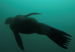
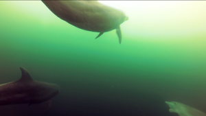
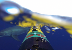
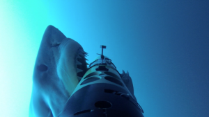
Figures 28-31. Top running clockwise: Sea Lion was captured on camera; a great white shark checking out our AUV from behind; dolphins filmed swimming in an oil slick in the Gulf of Mexico; OceanEye getting attacked by a white shark and lived to tell about it.
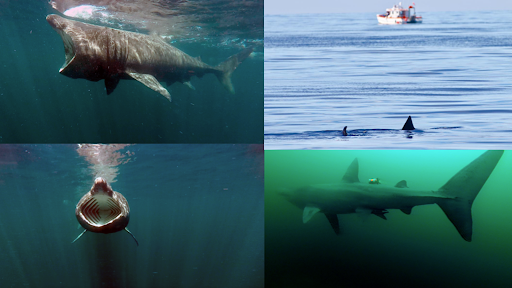
Figures 32-35. Basking shark filmed feeding near the surface in Scotland; Basking shark breaks the surface; basking shark swims into view with its mouth agape and our retag is seen on the 30 foot long basking shark.
Biologger Tags
Our lab has developed a number of specialized tags that record temperature, depth, time, acceleration, movement and also contain acoustics for communication between the OceanEye robot that can follow the tag for up to 24 hours in its current configuration. See our website for more information.
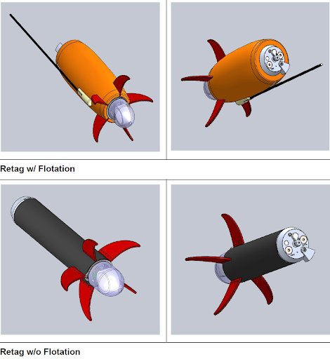
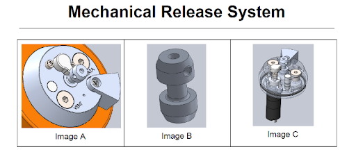
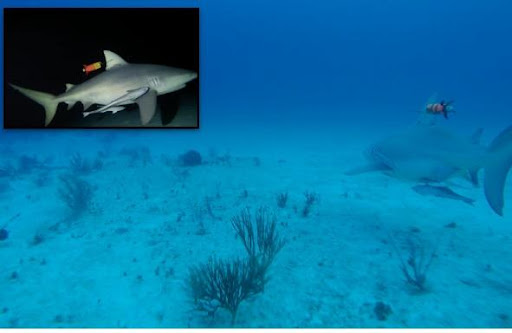
Figure 36-38. Shows a CAD view of our tag’s shape with and without flotation in its intramuscular dart configuration. Figure 37. The Retag has a three-tiered release system allowing for on-demand release or backups tied to battery or depth state and an expendable link. Figure 38 shows Retag on a bull shark in the Bahamas in 2018.
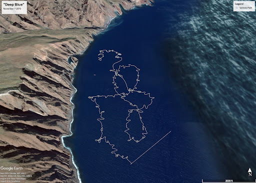
Figure 39. The Google map above shows a multi-hour track with fine scale resolution position tracks captured by the SharkCam AUV of Deep Blue, a 20 foot female white shark discovered by the WHOI research team and their collaborators on the making of Jaws Strikes Back for Discovery Channel in 2013.