Experimental Plan
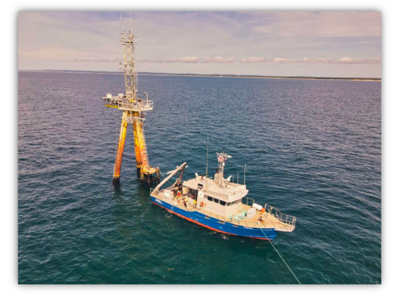
WHOI’s offshore Air-Sea Interaction Tower (ASIT) and the Research Vessel Tioga. (Photo credit Appledore Engineering)
WFIP3 will collect detailed observations of the atmosphere and ocean over a 12- to 18-month study period, and include both detailed model-based assessments of planetary boundary layer (PBL) scheme improvements and a number of coupled wind-wave-ocean or wind-wave models that will take advantage of these improvements.
The field study has two goals:
(1) detailed sampling of the vertical structure of the MABL at key observational areas, creating a rich dataset that will be used to refine and validate PBL schemes, and
(2) wide-area sampling of the MABL to create a multi-scale array of observations informing and guiding models of resource characterization.
We will:
- Collect detailed measurements of momentum, heat, and mass fluxes at multiple levels using in-situ and remote sensing (e.g., doppler lidars, doppler radars, and passive infrared and microwave spectrometers) of the MABL vertical structure from coastal land sites and two offshore towers at the Air-Sea Interaction Tower (ASIT) and on a large Barge.
- Carry out wide-area sampling of the coupled atmosphere and ocean boundary layers using lidar buoys, an array of surface flux buoys, as well as nearby land-based profiling and scanning observational systems.
- Conduct coordinated in situ sampling of the vertical structure of the MABL and beyond via rawinsonde launches from Martha’s Vineyard and during Intensive Operating Periods (IOPs) during ship-based transects.
- Utilize satellite-based remote sensing products (e.g., SST), adding wide-area sampling of the ocean surface winds via HFR-based wind observations and satellite-based flux products to enhance the in situ observations.
- Leverage the historical record of metocean and surface flux observations in the region.
These efforts will fully characterize the MABL within and surrounding the lease areas via a unique, coordinated observational strategy.
Our modeling program will improve wind resource assessment and forecasting of the MABL by improving model physics and model coupling, supported by quantitative evaluation of these improvements for key conditions or events that affect wind energy over the mid-Atlantic Outer Continental Shelf using the field study observations. Two parallel paths (coupling and parameterization) will be pursued, each using compatible grids to enable cross-integration of these components.
In addition, the project partners will also evaluate impacts of data assimilation on wind power forecasts, study uncertainty quantification of model forecasts, and develop novel wind-wave-wake coupling strategies. Modeling activities will revolve around the WRF-ARW model and/or NOAA’s RRFS model, coupled with ROMS, Wavewatch III, or a nested LES model system.