Field Observations
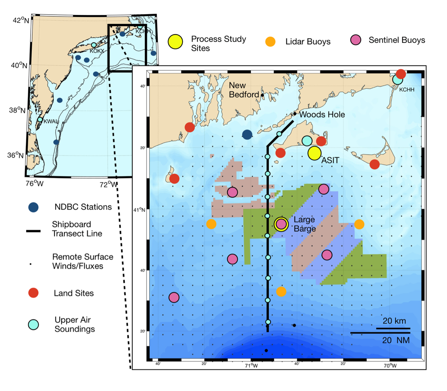
The WFIP3 deployment strategy will place instruments at locations in and near existing wind energy lease areas along the northeast US continental shelf.
Marine Atmospheric Boundary Layer Vertical Structure
- Offshore Air-Sea Interaction Tower: The project will leverage WHOI’s Air-Sea Interaction Tower (ASIT) to make detailed observations of air-sea fluxes at heights of 10 and 20 m asl which, along with surface skin temperatures and wave and current observations will allow momentum and heat fluxes to be observed directly along with remote scanning or profiling instrumentation.
- Offshore Barge: Deployed offshore to provide ASIT-like observations of the MABL for targeted periods during the field year, a barge will be used to support intensive observations of the MABL vertical structure during two 60 day periods (April-June and July-August).
- Detailed Atmospheric Soundings will characterize the MABL through both remote sensing and rawinsonde launches. The active and passive remote sensors will be run 24/7 on land-based sites and when the large barge is deployed. This work will leverage the seasonal (January, April, July and October) NSF-funded, ship-based, cross-shelf transects of the study area to collect detailed observations of atmospheric horizontal variability with soundings. Coincident soundings will be launched from WHOI or Martha’s Vineyard.
Multi-scale Array
- At-sea Buoys: Three lidar wind profiler buoys, seven surface buoys, and two sub-surface buoys will be moored in a distributed pattern the study region to resolve multi-scale variations in winds, surface meteorology, momentum and heat fluxes and ocean waves.
- Land-Based Field Stations: Six shore-based field sites, stretching from Nantucket to Rhode Island, will provide observations of the MABL using vertically-profiling and scanning lidars, thermodynamic profilers, surface radiometers (longwave and shortwave radiation), precipitation sensors, and more. Four of these sites currently host high frequency radar systems that will provide distributed ocean surface currents and experimental spatially dense surface wind products.
Timeline
The project field plan timeline includes the planning, mobilization, deployment, maintenance, and recovery of field assets. DOE and NOAA lab tasks will mirror this existing timeline. Analysis tasks will be carried out in periods 3 and 4.
Satellite Data
The satellite remote sensing component of WFIP3 will be carried out by DOE-lab partner PNNL. Prior or during the WFIP3 field campaign, several developing satellite data applications will be researched that help increase the knowledge of offshore wind conditions in the region.

