Analysis and Interpretations
Conclusions
 ADCP measurements reveal a surprisingly vigorous circulation in the Australian sector of the Southern Ocean. Traditionally, Southern Ocean transport estimates are made with a deepest common level applied to geostrophic shears. Generally, this yields transports comparable to measured transport at Drake Passage – or in the case of the Australian sector the Drake Passage transport plus a compensation for the Indonesian throughflow. The ADCP data from two sections south and south- 66 west of Australia show that the deepest common level referencing underestimates the eastward transport elements and misses westward transport elements.
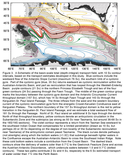
Here are the principal circulation elements that largely shape the circulation field that we have mapped on Fig. 3:
A strong cyclonic gyre is revealed south of the belt of eastward transport attributable to the Antarctic Circumpolar Current. The gyre’s eastward limb is parallel to the Circumpolar Current, and is part of a belt of eastward transport that reaches 271 ± 49 Sv south of western Australia, significantly larger, by more than 120 Sv, than the combined Drake Passage and Indonesian throughflow compensation. The opposing limb of the cyclonic gyre is a 76 ± 26 Sv westward flowing Antarctic Slope Current. To the north of the eastern transport belt 38 ± 30 Sv flows west as part of the an Indian Ocean Subantarctic Zone recirculation gyre. The resulting net flow south of Australia is 157 ± 58 Sv, a number similar to deepest common level referenced net transport of 180 Sv (provided an allowance is made for the missed westward transport of the Antarctic Slope Current unsampled south of the section). But the resulting circulation fields are very different because that approach significantly underestimates the eastward flow strength in the cyclonic gyre and underestimates or even reverses the westward flow in the far south.
The cyclonic gyre partially closes with northward flow in a western boundary current off the east coast of Kerguelen Plateau. That current’s initial transport, 48 ±6 Sv near 58ºS, is boosted by 38 Sv of eastward transport through the Fawn Trough, which bisects the Plateau near 56ºS. The combined flow, 86 ±18 Sv encounters the Antarctic Circumpolar Current and other eastward flowing waters (total 181 Sv) that enter the Australian–Antarctic Basin through the Kerguelen–St Paul Island Passage north of Kerguelen Plateau. That encounter is an energetic Crozet–Kerguelen Confluence that meanders northeast from 54ºS.
The cyclonic gyre’s closure within the Australian–Antarctic Basin is only about 40% of the maximum gyre transport. The other 60% of the transport is linked to the Weddell Gyre west of Kerguelen Plateau. That gyre may approach 100 Sv amplitude, although the most recent best estimate is 56 ±8 Sv (Klatt et al., 2005). Together the two gyres represent an elongated cyclonic system with two transport centers, one in each basin, and with a connecting bridge of 60% of the maximum strength, comprised of a westward flow over the Antarctic continental slope in the southern Princess Elizabeth Trough, and eastward transports in the northern Princess Elizabeth Trough and through the Fawn Trough. The cyclonic gyre appears to be only partly diminished in the eastern Australian–Antarctic Basin, by our interpretation of sections near 140ºE and 160ºE, and is inferred as having a projection into the Ross Gyre of the Pacific sector of the Southern Ocean perhaps reaching 40 Sv.
Dense bottom water is carried around the cyclonic gyre within the Australian–Antarctic Basin. Along the Crozet–Kerguelen Confluence the bottom water is folded under the lighter Antarctic Circumpolar Current waters flowing through the Kerguelen–St. Paul Island Passage, an interaction producing a vertical mixing signature in the potential vorticity distribution. Bottom water escapes the Australian–Antarctic Basin by two pathways, the long recognized pathway across the Southeast Indian Ridge at the Australian–Antarctic Discordance, where a transport of 4 Sv is estimated to crossover the Ridge to flow northwest to the Perth Basin, and a 6 Sv flow hypothesized through the Geelvinck Fracture Zone which is a narrow passage penetrating the Ridge Northeast of Kerguelen Island, with 2 Sv of that flow delivered to the Perth Basin.
The least well determined/ observed parts of the system are the westward flow along the Antarctic continental slope, the separation point and other structural aspects of the western boundary current system off the Kerguelen Plateau, the speculated northward dense flow through the Geelvinck Fracture Zone, the structure an amplitude of flows crossing the Southeast Indian Ridge at the Antarctic Discordance and the nature of the eastward closure of the cyclonic gyre.