DeepArgo
The DeepArgo Mission
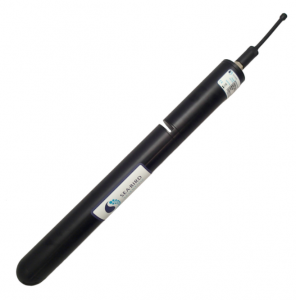
The Deep Argo Mission aims to collect full-ocean depth data globally with the help of partner institutions who also contribute to the OneArgo program. The DeepSOLO float, manufactured by MRV systems and pictured to the right, is used at WHOI for deep ocean data collection.
Deep Argo floats are quite different than their shallower-profiling counterparts that make up WHOI's Core Argo fleet. Typical Argo floats are long and cylindrical autonomous instruments that measure oceanic pressure, temperature, and conductivity down to a depth of 2,000 meters. The average depth of the ocean is approximately 4,000 meters, meaning the core Argo fleet collects data in the upper half of the ocean. DeepSOLOs, on the other hand, with their maximum depth of 6,000 meters, are capable of collecting full-ocean-depth data and some!


Why Deep Argo?
Similar to rivers on land, oceanic currents are rivers that move large quantities of water in specific paths. These currents can exist both at the sea surface and the deep ocean, often travelling vast distances and mixing water both horizontally and vertically. As these large water masses are moved throughout the world's oceans, both heat and salinity get transported. Generally, warm, salty surface waters near the equator move to the poles where they meet influxes of colder, fresher water masses. Some large-scale ocean circulation patterns, like the Meridional Overturning Circulation (MOC, aka Thermohaline Circulation), are global and play a significant role in oceanic heat and salt transport.
Systematic, global observation of the full water column with DeepArgo measurements will provide not only regional data, but a mesh of data worldwide which will then feed forward into closing global heat, freshwater, and steric sea level budgets -- in other words, scientists will be able to better understand how these large-scale circulations ultimately impact the ocean's temperature, melting of ice at the poles, and sea-level rise, among other data products.
Design Overview
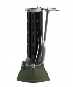
Due to the extreme pressure instruments experience at 6,000 meters, the Deep Argo program float has a design different than that of the shallower, core S2A floats. The glass-sphere hull of the DeepSOLO float, beneath a protective "hard hat" layer (see diagram to the right), is designed to evenly distribute the immense pressure experienced at depth, keeping the inside electronics safe and ensuring the float can continue cycling through the water column.
DeepSOLO uses a SBE-61 CTD, a deeper-diving version of the SBE-41.

DeepSOLO diagram courtesy of Journal of Atmospheric and Oceanic Technology 36, 10; 10.1175/JTECH-D-19-0066.1
BioGeoChemical (BGC) Argo
What is BioGeoChemical Argo?
Biogeochemical Argo floats are autonomous instruments that drift through the ocean, collecting critical data on the chemistry and biology of seawater in the upper 1000 meters of the water column. Unlike standard Argo floats, which primarily measure temperature and salinity, the suite of sensors on BGC floats can collect data on oxygen levels, pH, nitrate concentrations, chlorophyll, and particle backscatter. This information helps scientists understand how the ocean stores carbon, supports marine ecosystems, and responds to a changing environment. By capturing data in remote or hard-to-access regions over long periods, biogeochemical floats are transforming our understanding of ocean health and helping to build better models for predicting Earth’s climate future.
As part of the OneArgo program, the Global Ocean BioGeoChemistry Array, GO-BGC, will deploy 500 BGC floats between 2021-2026. See the GO-BGC website for more information, to access GO-BGC data, and to participate in our classroom outreach by adopting a float!
WHOI's BGC Argo Fleet
WHOI currently uses two types of BGC Argo floats. The Navis BGC (black float, manufactured by SeaBird) and the S2BGC (white float, manufactured by MRV). Note the sensors mounted on the outside of the pressure hull. See below or visit the Global Ocean Biogeochemical Array website, GO-BGC, for more information of the types of instruments employed on our floats and how they help us understand ocean biology and chemistry.

How do BGC sensors help us understand the ocean?
Note the diagram to the left. The warm, sun-lit surface waters of the ocean -- called the euphotic zone -- are home various types of plankton (like coccolithophorids, diatoms, picoplankton, etc.), plant-like organisms which form a major component of the ocean food web and play an equally significant role in the removal of carbon dioxide from the atmosphere through photosynthesis, just like trees on land! As phytoplankton grow they take in carbon dioxide (CO2) and produce oxygen (O2) in a process called respiration. They then use the CO2 they have taken up to build their bodies, thus sequestering the carbon. As phytoplankton die and sink to the seafloor this carbon gets locked away in the deep ocean, but this makes up only part of the sequestering process. Zooplankton, larger organisms that feed (graze) on phytoplankton, migrate from deeper ocean waters to the surface to feed every day in a process called the diel vertical migration. As these zooplankton sink back down to deeper waters, they sequester carbon by bringing the phytoplankton they have eaten down with them. As zooplankton die deeper in the water column, we get more carbon sinking to the seafloor. As all of these organisms defecate, die, and/or decompose at any level in the water column, they produce Dissolved Organic Carbon (DOC) and Particulate Organic Carbon (POC) which also plays a role in carbon capture, helped along by microbes and bacteria that recycle the carbon until it finally continues its journey sinking to the seafloor.
This extremely complicated process (greatly simplified in this explanation) is known as The Biological Pump.
As the BGC floats sink and rise through the water column, they track nitrate (a nutrient essential for plankton growth), oxygen (to monitor for low- or no-oxygen zones, aka "hypoxic" zones which kill organisms in the water that need oxygen to breathe), pH (this helps us measure acidity--acidic oceans have potential to kill ocean life both small and large), and chlorophyll (a sign of phytoplankton), among other things. These measurements help scientists understand how much carbon the ocean can absorb, how healthy marine ecosystems are, and how these systems are changing in response to our changing climate.
BGC Sensors
The Navis and S2BGC versions of WHOI's BGC Argo fleet have slightly different sensor packages. Navis BGC floats have 5 sensors (pH, oxygen, nitrate, a multichannel fluorometer, and CTD), while S2BGCs have a 6 sensor package (pH, oxygen, nitrate, a multichannel fluorometer, radiometer, CTD). Below you can see examples of the types of sensors onboard, and how exactly they help scientists understand our changing oceans. Note that all floats in the WHOI fleet have a CTD, a Conductivity, Temperature, and Depth sensor.


Oxygen [O2] Sensor
This is an SBE 63 Oxygen sensor. Oxygen sensors allow scientists to monitor for low- or no-oxygen zones, aka "hypoxic" or "dead" zones, among other things. Fish and other marine life depend on oxygen to survive, therefore when dead zones develop they are forced to move to a different habitat or die. Monitoring for dead zones helps us gauge the health of the ocean. See the BGC Argo Oxygen page for more info.
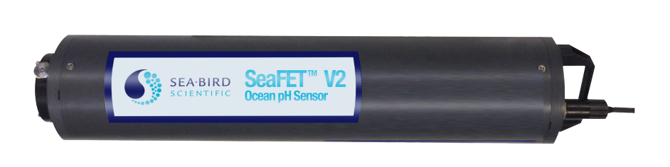
pH SENSOR
This a one type of pH sensor, a SeaBird SeaFET. pH sensors allow scientists to determine how acidic the ocean is--acidic ocean waters are a consequence of increased carbon dioxide (CO2) uptake at the surface. When waters become too acidic it affects the ability of organisms like coral, shellfish, and plankton to build their skeletons or shells, thus disrupting ecosystems. See the BGC Argo pH page for more details on pH sensors and how they work.


Radiometer - Downwelling Irradiance
Radiometers are a type of optical sensor that measure radiance and/or irradiance, this is a Seabird OCR-500. Floats in the BGC fleet equipped with these sensors measure downwelling irradiance: how far different wavelengths of light travel in seawater, and how much they scatter. This data can tell us many things: how many suspended particles are in the water, how much light is available for primary production, how much dissolved organic matter and/or plankton are in an area, what the water quality is like, etc. See the BGC Argo Downwelling Irradiance page for more info.

Fluorometer - Chlorophyll A [Chl A]
Fluorometers are a type of optical sensor, this is a .SeaBird ECO. BGC floats equipped with these sensors are configured to collect data on Chlorophyll A, a measure of phytoplankton biomass. Read more about the details of this measurement and the various ways it can be conducted at the BGC Argo Chlorophyll A Page.
Nitrate [NO2] sensor
Nitrate is an essential nutrient for phytoplankton, sensors like this Seabird SUNA, allow BGC Argo floats equipped with them to provide insight on how well plankton can thrive in an area. Nitrate sensors can also give us insight into upwelling, vertical mixing, and/or the stratification of a region. See the BGC Argo Nitrate page for more info on how nitrate can give us insights into ocean productivity, primary production, and more.
CTD SENSOR
CTD stands for Conductivity, Temperature, and Depth sensor, this is a Seabird SBE 41 CTD. With these three variables scientists can calculate Salinity. Temperature and Salinity measurements are crucial for ocean models, modern weather forecasting, and much more!
Sensor images courtesy of MRV and SeaBird