1996: IOEB Redeployed
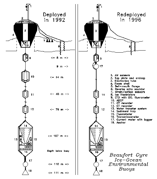
An Ice-Ocean Environmental Buoy (IOEB) was deployed in the Beaufort Sea in April 1992 at location 73.021 N, 148.828 W. Over the next four years, the buoy system drifted in a large generally clockwise arc, exceeding 82 N latitude in 1995, and finally drifted within 300 miles of the Canadian Archipelago in early 1996. Data was acquired and transmitted from numerous environmental sensors in the air, ice, and throughout the upper 110 m of the water column. A recovery/redeployment operation by a team of 4 scientists/engineers from Woods Hole Oceanographic Institution (WHOI) and Japan Marine Science and Technology Center (JAMSTEC) plus logistic personnel from Polar Associates (PAI) was launched as part of the AREA 96 operation in April 1996, with support by the U.S. Navy Space and Warfare Systems Command (SPAWAR) and the 109th Air National Guard. The Mould Bay Weather Station in northwest Canada provided our base for flight operations at the ice edge, and provide temporary accommodations and services. Using commercially contracted Twin Otter aircraft and a helicopter, 12 days of remote ice camp operations successfully recovered the system intact at location 79.362 N, 131.463 W. Several days later the refurbished system was redeployed at 79.117 N, 132.219 W, and subsequently transmitted a wealth of environmental data from the eastern Beaufort Sea pack ice for the next year.
The Beaufort Gyre IOEB demonstrated that IOEBs can survive unattended for at least 4 years in the Arctic pack ice, and provide multiyear timeseries of numerous environmental data in near-real time. This field operation has shown that air supported ice camps are not only an efficient means of deploying IOEBs, but also can be used for recovering, refurbishing, and reusing these units.
Survey of IOEB: April 11 to 14, 1996
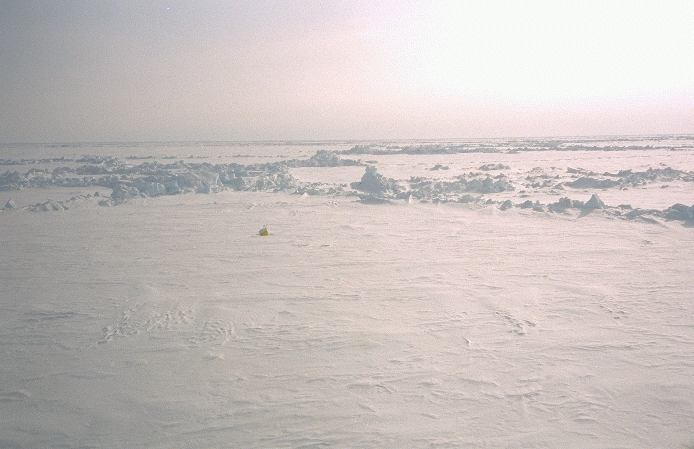
On April 12, the first survey was made to the latest buoy position, 79.50 N, 131.37 W, where the ice in this area was composed almost entirely of tightly packed, relatively small multiyear floes, with numerous, tall ridges. The larger sized floes and numerous leads which characterized the region where the IOEB was deployed four years previously, are absent from this location. The skies are clear, visibility excellent, and the yellow surface float is spotted within 10 minutes of reaching the site.
Next, a landing strip needed to be selected within a few miles of the IOEB, in order to allow sledging of our equipment between the strip and the buoy. After 45 minutes, Twin Otter pilot Harry Handlin selects a multiyear floe separated by 0.5 miles and several ridges from the buoy. The landing is rough which precludes using this site again, although the science party is able to visit the IOEB and examine the system visually. Covering this distance in about 15 minutes without equipment required climbing pressure ridges taller than 25 and bridging corresponding crevices along the way. It appears that there would be no reasonable way to shuttle equipment back and forth from this sight and our landing site with a snowmobile or by hand. The icefloe containing the buoy is estimated to be about 1/4 mile in diameter. Because transmissions from the tilt sensor of the IOEB indicated tilt of 40 deg, we expected the apex to be locked in a pressure ridge, but surprisingly, the it is at least 50 m from the edge of the floe.
The apex leans at a ~30-40 degree angle and is covered on top with 3-4" of light snow. It is positioned in a 6-8' diameter circular depression (1-2 deep) in the surrounding ice/snow surface; apparently caused by seasonal melting. However, because the yellow sides of the apex foam were exposed 3-5' all around, it was relatively easy to spot the unit from the air. The meteorological mast is bent approximately 45 deg, and the wind monitor is completely missing, the air thermistor hangs out from the damaged radiation shield. The foam flotation shows superficial polar bear claw marks, but is in excellent general condition, as are the top plate, patch antennas, and pickup chain. Next to the float, the aluminum pole and plate assembly which supported the under-ice echo sounder, protrude 4' above the ice, although none of the wires to any of the ice sensors are still connected to the apex, or are visible in the vicinity
The next afternoon (April 13) we arrive at the IOEB; again in excellent weather conditions. After circling for 15 minutes, a refrozen lead about 7.8 miles away from the buoy is selected. We land smoothly and set up temporary runway markers using black plastic trash bags filled with snow. Ideally the runway would be about 1800 long, but because this ice is so smooth it is acceptable, eventhough it is only about half that distance. The multiyear floe adjacent to the runway is also examined, and found acceptable for our scheduled air drop of fuel. No attempt to hike to the buoy is made this day, but we return instead to Mould Bay.
AMBER Ice Camp Established: April 15 to 18
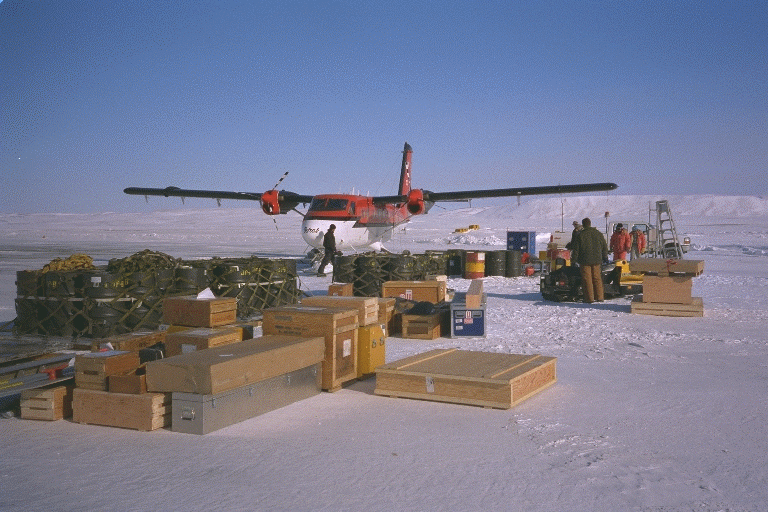
Within a few days, arrangements are made by PAI with Canadian Helicopters for a Bell 206 single-engine helicopter to support our operation. Meanwhile, our the 109th Air National Guard C-130 cargo arrives in Mould Bay with half of our cargo on April 15. Ted Gooch would coordinate the logistics between the ice camp, Mould Bay and Thule, while the rest of the science party was on the ice. This cargo is food, camp gear and fuel, and as soon as the pallets are offloaded unto the runway, we begin to pile the equipment into different Twin Otter loads. The first load is the pioneer load, and consists of a tent, radios, and food for two people to establish a base for a few days. The remainder of the camp gear will follow on the second flight, followed by the recovery gear, and finally, the redeployment equipment. One flight is made out to the landing strip on the ice to drop off the tent, floors, and poles while a second flight with fuel is made to Mercy Bay for a helicopter refueling cache.
The next morning, Kemp and Lord leave with the second cargo load to pioneer the ice camp (AREA 96 radio name AMBER) near the landing strip and prepare for the airdrop of fuel. Shortly thereafter another C-130 arrives from Thule with fuel and all our science gear. On the second Twin Otter flight, most of the remaining camp gear is transported to AMBER.
On April 17, Hatakeyama and Krishfield arrive at AMBER in the morning and assist assembling the second tent. Although the command tent was assembled on one side of the lead runway the previous evening, the second (work) tent was assembled on the other side, in order to provide a thicker icefloe (13 ) to deploy the buoy through. As a result, the two tents comprising the AMBER camp were a few hundred feet apart. Later the same day, forty 55 gallon barrels of JP-8 jet fuel are air dropped from a C-130 onto the multiyear icefloe adjacent to the runway, in groups of four per pallet with attached parachute. The remainder of the day is spent by the ice party recovering the barrels and creating a depot of fuel by the lead, while the next day is spent finishing the AMBER camp setup, including grooming a minor ice ridge in the runway.
Recovery of IOEB: April 19 to 22
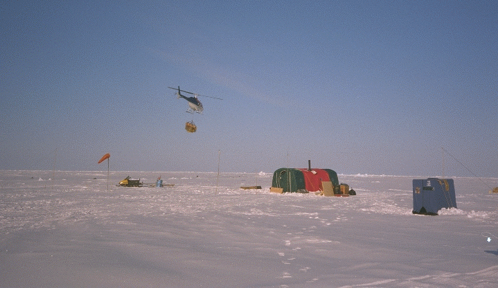
On Friday (April 19), another Twin Otter flight brings out the remainder of the redeployment gear, which is stored in the work tent. In the afternoon, the helicopter arrives and we begin moving our recovery gear to the IOEB site. Most of our gear is too large to fit inside the helicopter, so we have to sling it below. The maximum weight that can be loaded into or onto the aircraft is between 800 and 1000 lb., thus requiring two days to move the 5000 lb. of gear we need for the remote camp, and to recover the IOEB. In fact, as the day goes on, the skies become more overcast, and visibility decreases, which makes it difficult for the pilot (Dave Nasogaluak) to discern the horizon from the ice. Consequently, once the temporary camp gear is transported to the IOEB site, Kemp and Lord fly over on the last flight to pioneer the remote recovery camp and spend the night there. For the next few days, those two will sleep there, while the rest of the ice party will sleep at AMBER and work during the day at the remote IOEB site. This reduces the amount of time required for the set up and break down of the remote camp. The next day (April 20), we finish moving our gear on 5 more helicopter flights. The gantry and winch are assembled and the ice anchor tierods are drilled and filled with fresh water, to be frozen in place overnight.
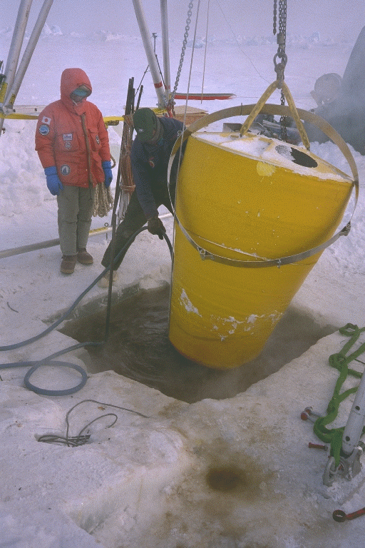
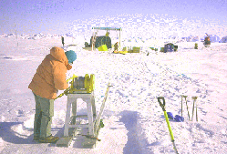
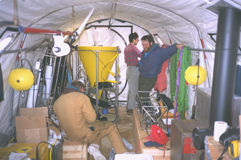
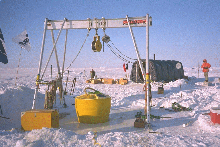
On Sunday, April 21, the actual recovery of the IOEB begins around 10 AM (local). The day is generally partly cloudy, with the air temperature hovering between -20 and -25 deg C. The hot water drill is powered and begins cutting a 50? hole in the ice around the buoy, despite difficulty getting the ring to penetrate straight down around the leaning apex. Wires from the ice sensors installed four years ago are frozen everywhere in the ice around the buoy and sometimes inhibit the ice drill, and have to be manually removed. Below the bellmouth (around 2 ft.), the hose is disconnected from the ring, and the spray melts the ice around the bellmouth. When the bellmouth comes free, we are able to hang it straight from the gantry. The bellmouth covers are removed, ice which formed in the flange is melted out, as is the clevis connection at the bottom of the apex. The water cuts a hole down through the center of the ice hole, and salt water fills the recovery well. Consequently, it takes another three hours to cut through the remaining 3' of ice hole using the 50" drill ring. The ice plug is frozen to the blue cable, thus is raised by lifting the mooring. It is cut into pieces with chainsaws and the debris dragged away. Recovering the instruments ends up being straightforward, and the mooring system is retrieved intact, making sure that each instrument is hauled into the tent immediately upon reaching the surface, in order to keep from freezing. By 7 PM local (April 21, 23:00 Z) we are finished with the recovery. After a short break, we rip down the gantry and winch, and pack up most of the gear. The following day (April 22), everything is transported via helicopter back to AMBER and the IOEB remote location is completely abandoned. Also, a Twin Otter arrives with Nakamura and other miscellaneous gear, finishing our uphaul operation and completing our ice party.
The first priority back at AMBER was to dump data from any instruments, and remove old batteries. In all cases, both the main and backup batteries had expired in all the underwater instruments. Only the ADCP contained non-volatile bubble memory, but data collection from that instrument was not attempted in the field. All other instruments only provided garbage data when provided with external power. This was to be expected, since the time after the deployment was double the expected lifetime of the sensor battery packs. In addition, no sediment trap or pump samples were acquired, due to the network noise and a software error mentioned before.
Redeployment of IOEB: April 23 to 27
An Ice-Ocean Environmental Buoy (IOEB) was deployed in the Beaufort Sea in April 1992 at location 73.021 N, 148.828 W. Over the next four years, the buoy system drifted in a large generally clockwise arc, exceeding 82 N latitude in 1995, and finally drifted within 300 miles of the Canadian Archipelago in early 1996. Data was acquired and transmitted from numerous environmental sensors in the air, ice, and throughout the upper 110 m of the water column. A recovery/redeployment operation by a team of 4 scientists/engineers from Woods Hole Oceanographic Institution (WHOI) and Japan Marine Science and Technology Center (JAMSTEC) plus logistic personnel from Polar Associates (PAI) was launched as part of the AREA 96 operation in April 1996, with support by the U.S. Navy Space and Warfare Systems Command (SPAWAR) and the 109th Air National Guard. The Mould Bay Weather Station in northwest Canada provided our base for flight operations at the ice edge, and provide temporary accommodations and services. Using commercially contracted Twin Otter aircraft and a helicopter, 12 days of remote ice camp operations successfully recovered the system intact at location 79.362 N, 131.463 W. Several days later the refurbished system was redeployed at 79.117 N, 132.219 W, and subsequently transmitted a wealth of environmental data from the eastern Beaufort Sea pack ice for the next year.
The Beaufort Gyre IOEB demonstrated that IOEBs can survive unattended for at least 4 years in the Arctic pack ice, and provide multiyear timeseries of numerous environmental data in near-real time. This field operation has shown that air supported ice camps are not only an efficient means of deploying IOEBs, but also can be used for recovering, refurbishing, and reusing these units.
AMBER Ice Camp Evacuated: April 27 to 28
The following day (April 28), several flights are performed late to remove the remainder of the cargo, and the rest of the ice camp party. On May 1, Mould Bay is evacuated by C-130 of all IOEB gear and ice camp personnel back to Thule, Greenland. Two days later, the WHOI and JAMSTEC personnel are back in the continental US.
Throughout the next year, nearly all of the instruments transmitted reliable data. The network noise and various software errors which disrupted the 1992 system were repaired on the 1996 system. Both PTTs and controllers on the IOEB functioned properly, and the remaining instruments telemetered information from 69 environmental variables. Included in this information is the rotation of the sediment traps to their respective cups, on schedule. In addition, field measurements of the air temperature, barometer and wind monitor all agree with the corresponding IOEB data, and the earliest transmitted SeaCat data agrees with data from the CTD cast taken shortly before redeployment. On the other hand, both S4 current meters malfunctioned, and there are a couple of questionable ice thermistors.
