Deep Madagascar Basin Experiment
Deep Madagascar Basin (DMB) Experiment: A Quest to Find the Abyssal Water Pathways in the Southwest Indian Ocean
Viviane Menezes, Heather Furey, Amy Bower (WHOI), Matthew Mazloff (Scripps)
Contact: Viviane (vmenezes@whoi.edu) or Heather (hfurey@whoi.edu)
Proposal Summary
Overview: The deep and abyssal (> 4000 m) oceans both store and redistribute heat, freshwater, carbon, and other substances, and play a crucial role in regulating the Earth’s climate on multidecadal to millennial timescales. Repeated hydrographic observations from the last three decades have revealed compelling evidence of changes in these deep oceanic layers. Read More
Intellectual Merit: The proposed research will investigate the largely unknown DMB abyssal circulation, how abyssal temperature varies in the DMB interior and the effects of the tortuous seafloor topography in steering the DMB abyssal flows. The primary objective is to find out by which pathway(s) the CFC-rich abyssal water that enters through deep fracture zones in the Southwest Indian Ridge (SWIR) spreads in the basin, which is crucial for a better understanding of the IMOC and its variability. Two existing, and conflicting, hypotheses guide the proposed work. One hypothesis is that a continuous, narrow, well-defined, and permanent Deep Western Boundary Current transports this water. A second hypothesis is that a northwestward interior flow between 30ºS-23ºS also exists, and contributes to the spreading of younger abyssal waters across the DMB. To determine the pathways and the transformation of the abyssal waters in the DMB interior an array of 75 neutrally buoyant RAFOS floats and 3 deep SOLO Argo floats will be deployed, complemented by hydrographic sections (including tracer analysis) across the mid-basin and the fracture zones. The in-situ observations will be paired with a state-of-art modeling component, which will be used to investigate the underlying dynamics and time evolution of the deep flow field. The proposed research will be a US contribution to the 2nd International Indian Ocean Expedition (IIOE-2) and will provide the first direct estimate of the abyssal circulation and temperature variability in the DMB on a basin-scale. It will also give the first quasi-synoptic volume transport estimates of the three most significant fracture zones in the SWIR, which are vital to quantifying the IMOC strength.
The DMB Observational Experiment
The observational program consists of: (a) 75 Lagrangian RAFOS floats, which will map out the flow and temperature fields at one pressure level; (b) a high spatial resolution CTD survey, to provide full-water column snapshot of ocean properties; (c) Three Deep SOLO Argo floats. The observational program will be implemented using a single 24-day cruise stationed out of Port Louis, Mauritius.
Map of the DMB field program, along with trajectories of all virtual floats at 4100 m deployed inside the fractures zones that reached the DWBC. Red is used for floats that were initialized at the Atlantis II, blue for Novara and Green for Melville. ETOPO-2 bathymetry is shaded every 1000-m. The A-, N-, M-sections will have five CTDs each; the X-section will consist of 24 CTD stations and RAFOS float deployment will be performed along this section. In the western end of the X- section, the CTD stations will be more closely spaced. The white boxes indicate the fracture zone exits where RAFOS floats and deep SOLO Argo floats will be deployed.
Highlighted Publications
Furey, H. H., Pinckney, A., Bower, A., & Menezes, V. V. (2026). Deep Madagascar Basin Experiment: RAFOS Float Data Report April 2023 - April 2025. Woods Hole Oceanographic Institution. https://doi.org/10.1575/1912/72924
Menezes, V., H. Furey, D. Torres, F. Bahr, and L. Baker, 2026. Direct Observations of Strong Jets Transporting Deep and Bottom Water into the Indian Ocean through the Fracture Zones of the Southwest Indian Ridge. Journal of Geophysical Research-Oceans, https://doi.org/10.1029/2025JC023864.
Menezes, V., Furey, H., Davies, A., Bahr, F., Torres, D., Happell, J., Mau, A., Barna, A., Roadman, M., Chung, K., Matthews, N., Shangheta, L., Desbonnes, O., Cruz, A., Tinari, A., Baker, L., Ellison, L., Reynard, N., Brokensha, R., Aratra, V., Canivete, G., Andrade, A., Mullen, A., & Buthelezi, A. (2025). Deep Madagascar Basin Expedition Cruise Report. Woods Hole Oceanographic Institution. https://doi.org/10.1575/1912/71975
Menezes, V. V., Robbins, P., Furey, H., & Mazloff, M. 2024. Deep argo observations of Antarctic bottom water in the deep fracture zones of the Southwest Indian Ridge. Journal of Geophysical Research: Oceans, 129, e2024JC021165. https://doi.org/10.1029/2024JC021165
Phillips, H., Menezes, V. V., Nagura, M., McPhaden, M., Vinayachandran, P. N., Beal, L. M. Indian Ocean Circulation. Chapter 8, p. 169-203. In: Ummenhofer and Hood - The Indian Ocean and its role in the global climate system, Elsevier, doi: 10.1016/B978-0-12-822698-8.00012-3, 2024
Students
Austin Krautkramer - Blue Economy Intern, Winter-Spring 2026
Somang Song - Visiting Student, September 2025-2026.
Thanda Newkirk - Summer Student Fellow, May-August 2020.
All Publications
- Almeida, L., Mazloff, M. R., & Mata, M. M., 2021. The impact of Southern Ocean Ekman pumping, heat and freshwater flux variability on intermediate and mode water export in CMIP models: Present and future scenarios. Journal of Geophysical Research: Oceans, 126, e2021JC017173. https://doi.org/10.1029/2021JC017173
- Almeida, L., Mazloff, M.R. and Mata, M.M., 2024. The influence of surface fluxes on export of Southern Ocean intermediate and mode water in coupled climate models. Journal of Geophysical Research: Oceans, 129(11), p.e2024JC021841.
- Cai, Y., Chen, D., Mazloff, M.R., Lian, T. and Liu, X., 2022. Topographic Modulation of the Wind Stress Impact on Eddy Activity in the Southern Ocean. Geophysical Research Letters, 49(13), p.e2022GL097859.
- Cerovečki, I., Sun, R., Bromwich, D. H., Zou, X., Mazloff, M. R., & Wang, S. H., 2022. Impact of downward longwave radiative deficits on Antarctic sea-ice extent predictability during the sea ice growth period. Environmental Research Letters, 17(8), 084008.
- Dinh, A., Rignot, E., Mazloff, M., & Fenty, I., 2024. Southern Ocean high-resolution (SOhi) modeling along the Antarctic Ice Sheet periphery. Geophysical Research Letters, 51, e2023GL106377. https://doi.org/10.1029/2023GL106377
- Dinh, A., Rignot, E., Mazloff, M. and Fenty, I., 2024. Modeling ocean heat transport to the grounding lines of Pine Island, Thwaites, Smith, and Kohler glaciers, West Antarctica. Geophysical Research Letters, 51(19), p.e2024GL110078.
- Ellison, E., Mashayek, A., & Mazloff, M., 2023. The Sensitivity of Southern Ocean Air-Sea Carbon Fluxes to Background Turbulent Diapycnal Mixing Variability. Journal of Geophysical Research: Oceans, 128, e2023JC019756. https://doi.org/10.1029/2023JC019756
- Ellison, E., Mazloff, M. and Mashayek, A., 2024. The rapid response of Southern Ocean biological productivity to changes in background small scale turbulence. Journal of Geophysical Research: Oceans, 129(10), p.e2024JC021158.
- Ellison, E., Mazloff, M. and Mashayek, A., 2025. Can Biogeochemical Tracer Observations Constrain Southern Ocean Diapycnal Mixing Rates?. Geophysical Research Letters, 52(7), p.e2024GL112706.
- Jeong, H., X.S. Asay-Davis, A.K. Turner, D.S. Comeau, S.F. Price, R.P. Abernathey, M. Veneziani, M.R. Petersen, M.J. Hoffman, M.R. Mazloff, and T.D. Ringler, 2020. Impacts of ice-shelf melting on water mass transformation in the Southern Ocean from E3SM simulations. J. Climate, https://doi.org/10.1175/JCLI-D-19-0683.1
- Kuhn, A.M., Mazloff, M.R., Gille, S.T. and Verdy, A., 2025. Sensitivity of chlorophyll vertical structure to model parameters in the Biogeochemical Southern Ocean State Estimate (B‐SOSE). Journal of Geophysical Research: Biogeosciences, 130(1), p.e2024JG008300.
- Luo, H., Yang, Q., Mazloff, M., Nerger, L., & Chen, D., 2023. The impacts of optimizing model-dependent parameters on the Antarctic sea ice data assimilation. Geophysical Research Letters, 50, e2023GL105690. https://doi.org/10.1029/2023GL105690
- Mazloff, M. R., Verdy, A., Gille, S. T., Johnson, K. S., Cornuelle, B. D., & Sarmiento, J., 2023. Southern Ocean acidification revealed by biogeochemical-Argo floats. Journal of Geophysical Research: Oceans, 128, e2022JC019530. https://doi.org/10.1029/2022JC019530
- Menezes, V. V., Robbins, P., Furey, H. and Mazloff, M. Deep Argo Observations of Antarctic Bottom Water in the Deep Fracture Zones of the Southwest Indian Ridge, J. Geophys. Res. – Oceans, 129, e2024JC021165, doi: 10.1029/2024JC021165, 2024
- Lanham, J., Mazloff, M., Naveira Garabato, A.C., Siegert, M. and Mashayek, A., 2025. Seasonal regimes of warm Circumpolar Deep Water intrusion toward Antarctic ice shelves. Communications Earth & Environment, 6(1), p.168.
- Nakayama, Y., Malyarenko, A., Zhang, H., Wang, O., Auger, M., Nie, Y., Fenty, I., Mazloff, M., Köhl, A. and Menemenlis, D., 2024. Evaluation of MITgcm-based ocean reanalyses for the Southern Ocean. Geoscientific Model Development, 17(23), pp.8613-8638.
- Narayanan, A., Gille, S. T., Mazloff, M. R., & Murali, K., 2019. Water mass characteristics of the Antarctic margins and the production and seasonality of dense shelf water. Journal of Geophysical Research-Oceans.doi: 10.1029/2018jc014907
- Narayanan, A., Gille, S. T., Mazloff, M. R., du Plessis, M. D., Murali, K., & Roquet, F., 2023. Zonal distribution of Circumpolar Deep Water transformation rates and its relation to heat content on Antarctic shelves. Journal of Geophysical Research: Oceans, 128, e2022JC019310. https://doi.org/10.1029/2022JC019310
- Narayanan, A., F. Roquet, B. Gülk, S.T. Gille, M.R. Mazloff, A. Silvano, A.C. Naveira Grabato, 2024. Ekman-driven salt transport as a key mechanism for open-ocean polynya formation at Maud Rise. Sci. Adv. 10, eadj0777(2024). DOI:10.1126/sciadv.adj0777
- Phillips, H., Menezes, V. V., Nagura, M., McPhaden, M., Vinayachandran, P. N., Beal, L. M. Indian Ocean Circulation. Chapter 8, p. 169-203. In: Ummenhofer and Hood - The Indian Ocean and its role in the global climate system, Elsevier, doi: 10.1016/B978-0-12-822698-8.00012-3, 2024
- Prend, C.J., MacGilchrist, G.A., Manucharyan, G.E. Pang, R.Q., Moorman, R., Thompson, A.F., Griffies, S.M., Mazloff, M.R., Talley, L.D., Gille, S.T. Ross Gyre variability modulates oceanic heat supply toward the West Antarctic continental shelf. Commun Earth Environ 5, 47, 2024. https://doi.org/10.1038/s43247-024-01207-y
- Rousselet, L., P. Cessi, and M. R. Mazloff, 2022: What Controls the Partition between the Cold and Warm Routes in the Meridional Overturning Circulation?. J. Phys. Oceanogr., 53, 215–233, https://doi.org/10.1175/JPO-D-21-0308.1.
- Shi, Q., Yang, Q., Mu, L., Wang, J., Massonnet, F. and Mazloff, M. Evaluation of Sea-Ice Thickness from four reanalyses in the Antarctic Weddell Sea. The Cryosphere, 15(1). doi: 10.5194/tc-15-31-2021. https://tc.copernicus.org/articles/15/31/2021/
- Taylor, B. A., MacGilchrist, G. A., Mazloff, M. R., & Talley, L. D., 2023. Freshwater displacement effect on the Weddell Gyre carbon budget. Geophysical Research Letters, 50, e2023GL103952. https://doi.org/10.1029/2023GL103952
- Twelves, A. G., Goldberg, D. N., Henley, S. F., Mazloff, M. R., & Jones, D. C., 2021. Self‐shading and meltwater spreading control the transition from light to iron limitation in an Antarctic coastal polynya. Journal of Geophysical Research: Oceans, 125, e2020JC016636. https://doi.org/10.1029/2020JC016636
- Twelves, A.G., Goldberg, D.N., Holland, P.R., Henley, S.F., Mazloff, M.R. and Jones, D.C., 2024. Chlorophyll production in the Amundsen Sea boosts heat flux to atmosphere and weakens heat flux to ice shelves. Journal of Geophysical Research: Oceans,129(9), p.e2024JC021121.
Funding
This project is generously funded by the National Science Foundation.

Project Summary
FIELDWORK UPDATE
May 2023: Cruise completed! 77 CTD/LADCP/tracer stations completed, 5 Deep Argo floats, 4 core Argo floats, 2 BGC floats, 36 RAFOS floats, 20 surface SVP drifters & 5 moorings deployed. A successful cruise and amazing data!
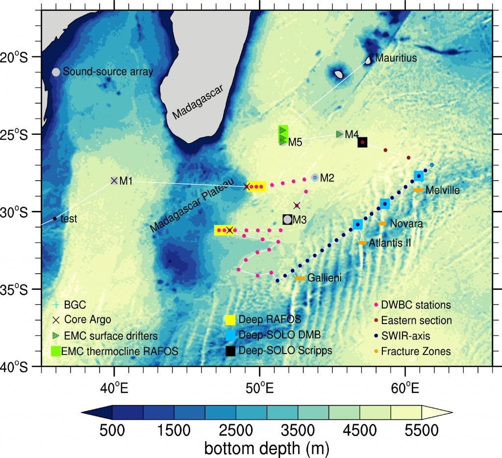
Figure: cruise track, stations occupied, and instrumentation deployed on RR2303 09 April - 13 May 2023.
Student Experience at Sea:
'Navigating her path of success in the field of Marine Science', August 2023. Amanda Buthelezi describes her experiences during the DMB field program. https://www.cput.ac.za/component/rsblog/navigating-her-path-of-success-in-the-field-of-marine-science?Itemid=101
DMB Cruise Data
Ship-collected CTD and bottle data from the R/V Revelle 2606 2023-04-09 to 2023-05-13 cruise are available at CCHDO: https://cchdo.ucsd.edu/cruise/33RR20230409.
The data may be cited as: Menezes, V. V., & Furey, H. H. (2025). Deep Madagascar Basin (DMB) Experiment: CTD and Discrete Bottle Hydrographic Data [Data set]. CCHDO: CLIVAR and Carbon Hydrographic Data Office. https://doi.org/10.7942/C20T04
LADCP Dataset: Menezes, Viviane, Daniel J. Torres, and Heather Furey. 2025. “Deep Madagascar Basin (DMB) Experiment - LADCP Data.” MBLWHOI Library Dataverse. https://dataverse.whoi.edu/dataset.xhtml?persistentId=doi:10.26027/DATA54LCZZ.
RAFOS Float Data: Furey, Heather, Pinckney, Anna, Bower, Amy & Menezes, Viviane, 2026, "Deep Madagascar Basin Experiment: RAFOS Float Data, April 2023 - April 2025", https://doi.org/10.26027/DATAPLAHCT, MBLWHOI Library Dataverse, V1


