UGOS (GODEEP/LC-Floats): Near Real-time Hydrography and Deep Velocity in the Loop Current System using Autonomous Profilers
Amy Bower (WHOI), Steve Jayne (WHOI), Heather Furey (WHOI). Collaborator: Paula Perez-Brunius (CICESE)
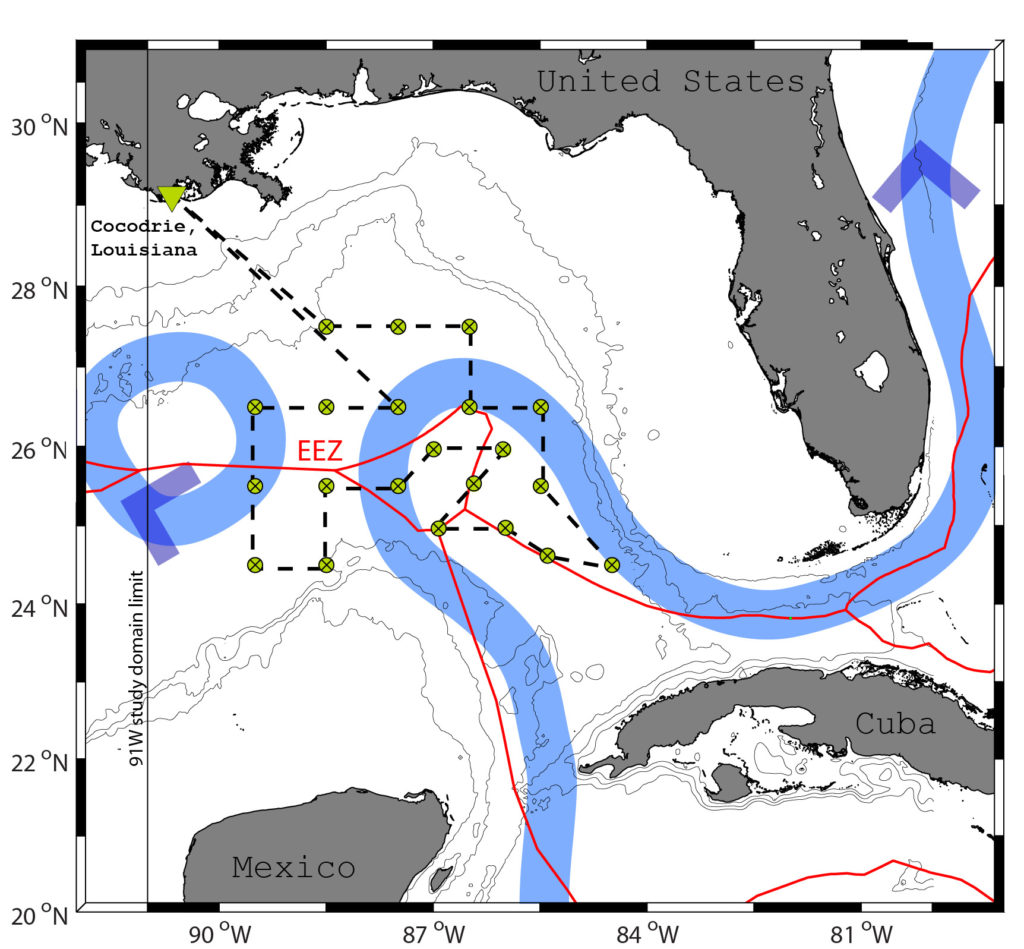 A fleet of 20-25 autonomous profilers deployed in the Loop Current System (LCS) active area in the eastern Gulf of Mexico are part of the NAS Understanding Gulf Ocean Systems campaign, and provide publicly-available near-real-time data to weather forecast models to aid in hurricane prediction. These data are also being used in conjunction with c-PIES data to explore the physical mechanism of Loop Current expansion into the Gulf and subsequent Loop Current Ring formation. Read More
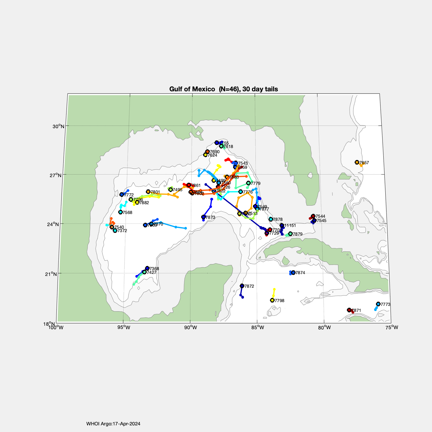
Current position of floats deployed to date:
*** ALSO INCLUDES FLOATS NOT PART OF UGOS PROGRAM ***
http://argo.whoi.edu/argo/maps/tails/GulfofMexico.png
GRIIDC Gulf Science Data Repository:
Bower, Amy S., Furey, Heather H., & Jayne, Steven R., UGOS S2A (SOLO) Profiling Float Data, doi: 10.7266/d4ehecf
WHOI-Argo webpages of the floats deployed to date:
Cruise 1, UGOS1, June 2019, R/V Pelican:
( 9 floats deployed, 8 successful )
7491 7492 7540 7541 7542 7544
7545 7568 7495 - dud
Cruise 2, UGOS1, September-October 2019, R/V Pelican:
( 12 floats deployed, 12 successful )
7495 7499 7513 7518 7556 7557
7559 7560 7561 7577 7584 7586
Cruise 3, UGOS1, September-October 2020, R/V Pelican:
( 4 floats deployed, 4 successful )
7519 7543 7538 7549
Cruise 4, UGOS1, May 2021, R/V Pelican:
( 4 floats deployed, 4 successful )
7618 7622 7623 7624
Cruise 5, UGOS3, October 2022, R/V Pelican:
( 8 floats deployed, 6 successful )
7690 7700 7701 7703-(dud) 7726 7729 7742 7755
Cruise 6, UGOS3, June 2023, R/V Pelican:
( 16 floats deployed, 16 successful )
7771 7772 7776 7779 7796 7801 7802 7877 7861 7873 7878 7879 7880 7882 7883 7884
Publications
Meunier, T., Bower, A., Pérez‐Brunius, P., Graef, F., & Mahadevan, A. (2024). The Energy Decay of Warm‐Core Eddies in the Gulf of Mexico. Geophysical Research Letters, 51(1), e2023GL106246.
Lermusiaux, P. F. J., Haley, P. J., Mirabito, C., Mule, E. M., DiMarco, S. F., Dancer, A., Ge, X., Knap, A.H., Liu, Y., Mahmud, S., Nwankwo, U.C., ... & Khadka, M. (2024, September). Real-time ocean probabilistic forecasts, reachability analysis, and adaptive sampling in the Gulf of Mexico. In OCEANS 2024-Halifax (pp. 1-10). IEEE.
Mule, E. M., Haley, P. J., Mirabito, C., DiMarco, S. F., Mahmud, S., Dancer, A., Ge, X., Knap, A.H., Liu, Y., Nwankwo, U.C., Glenn, S., ... & Lermusiaux, P. F. J. (2024, September). Real-time probabilistic reachability forecasting for gliders in the Gulf of Mexico. In OCEANS 2024-Halifax (pp. 1-10). IEEE.
Gewin, Virginia. “A Scientific “Forced Marriage” Takes on the Mysteries of the Loop Current.” Issues in Science and Technology 40, no. 2 (Winter 2024): 63–69. https://doi.org/10.58875/ZXHB9598
West-Mack, D., and H. Furey, 2023. PE23-23 Cruise Report UGOS GODEEP 2023 WHOI Cruise Report, June 2023, 21 pp.
Meunier, T., P. Perez Brunius, and A. Bower, 2022. Reconstructing the three-dimensional structure of loop current rings from satellite altimetry and in situ data using the Gravest Empirical Modes Methods. Remote Sensing, 14(17), 4174. doi.org/10.3390/rs14174174.
Furey, H., D. West-Mack, and P. Robbins, 2022. PE2307 Cruise Report UGOS GODEEP 2022 WHOI Cruise Report, 22 pp.
Figures
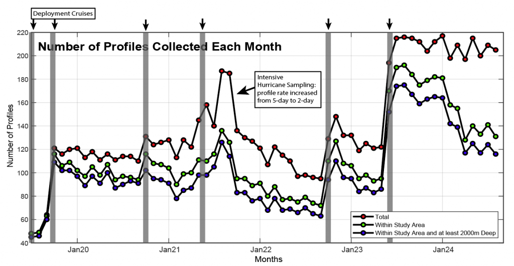 Time series of number of profiles collected by UGOS-funded Argo floats in the Gulf of Mexico from July 2019-August 2024. The red dots represent total profiles collected throughout the Gulf, the green dots represent number of profiles collected within the eastern Gulf only (between 90W and 81W), and the blue dots represent number of profiles collected within the eastern Gulf in water deeper than 2000 m.
Funding
This project is generously funded by the National Academy of Sciences.

Updates
January 2026: Amy Bower discusses the importance of the mysterious Loop Current alongside UGOS colleagues, Steve and Scott on the Sea Change podcast. Listen here!
July 2025: One never knows where an Argo float will go after deployment, but it is not typical for a float mission to include two visits aboard fishing vessels. Read more about the interesting journey of UGOS Argo float 7513 here.
![]()
Posters
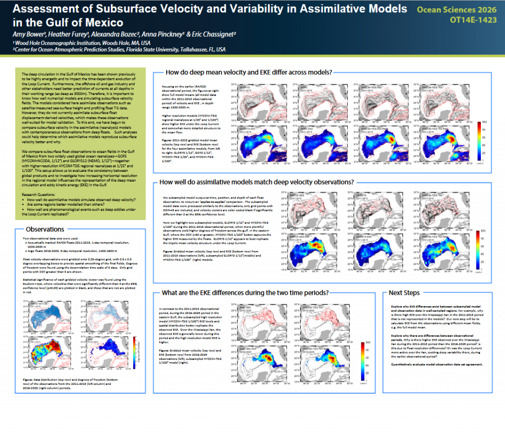
Assessment of Subsurface Velocity and Variability in Assimilative Models in the Gulf of Mexico, Poster, Ocean Sciences Meeting, 22-27 February, 2026, Glasgow, Scotland.
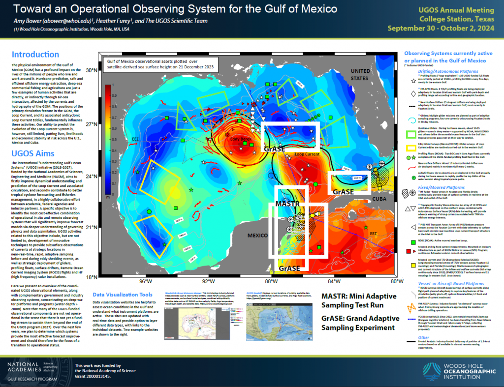
Toward an Operational Observing System for the Gulf of Mexico, Poster, UGOS Annual Meeting September 30-October 2, 2024, College Station, TX.
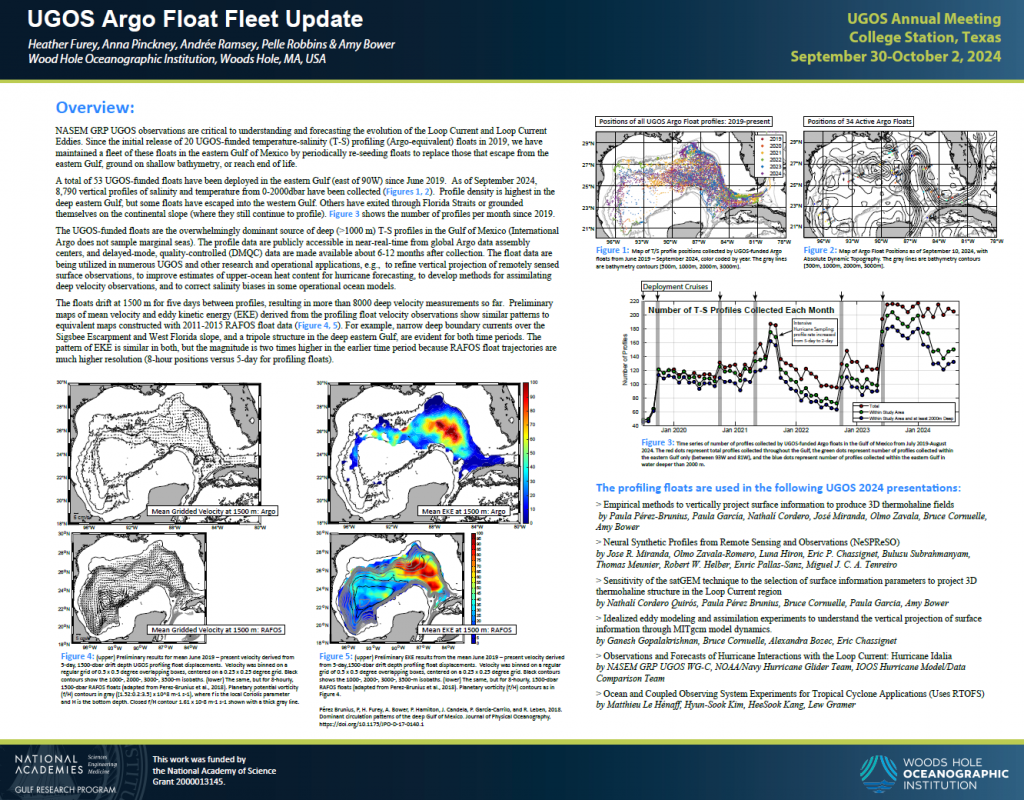
UGOS Argo Float Fleet Update, Poster, UGOS Annual Meeting September 30-October 2, 2024, College Station, TX.
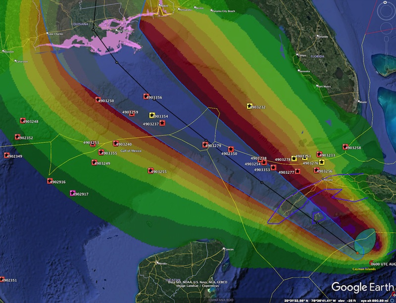
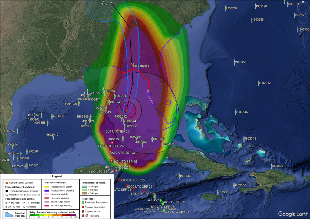
LC-Floats under hurricane paths:
September 2024 - Hurricane Helene
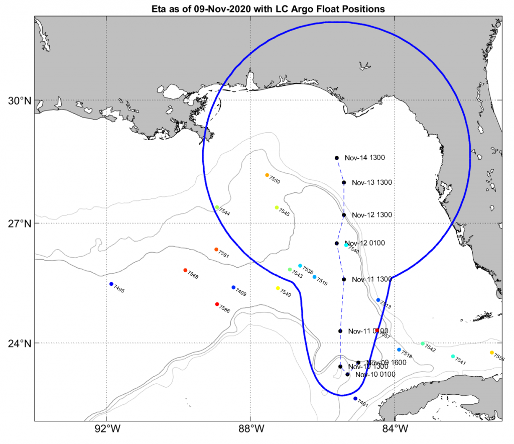
November 2020 - Hurricane Eta
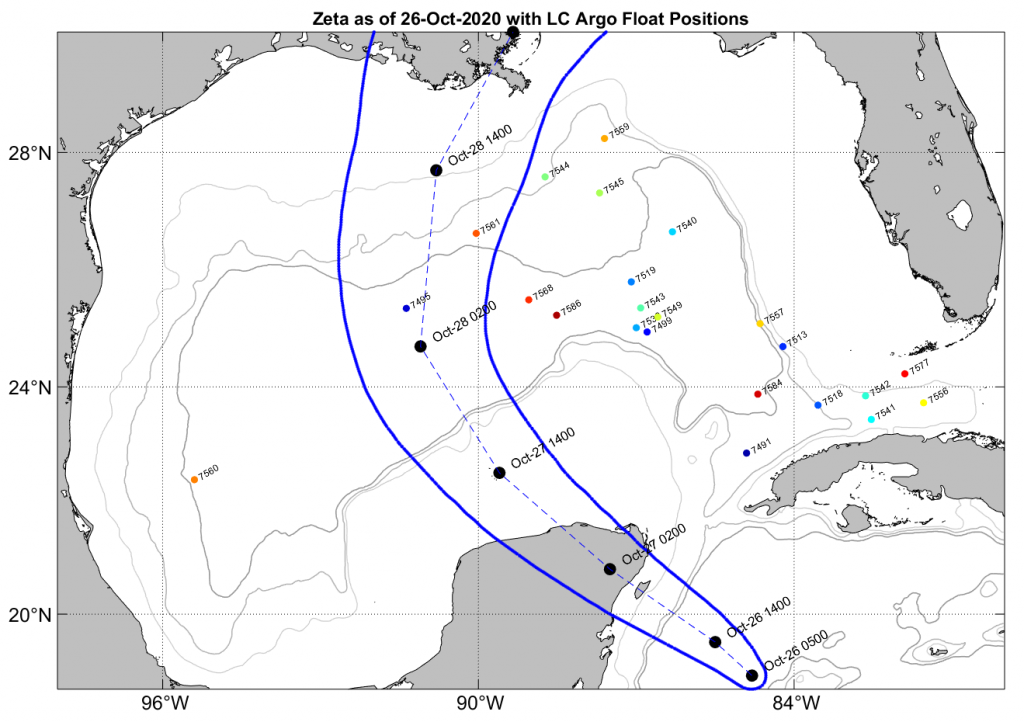
October 2020 - Hurricane Zeta
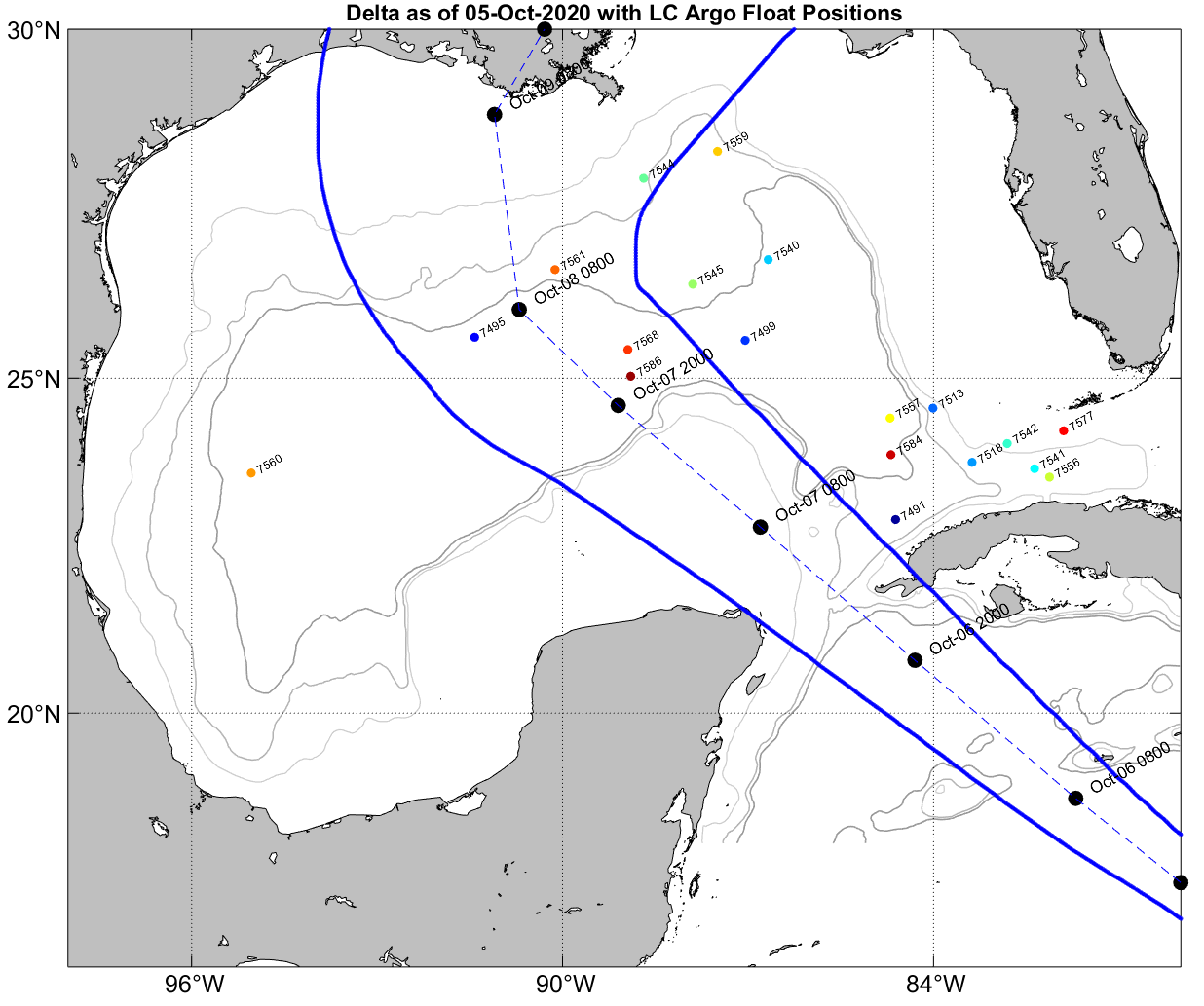
October 2020 - Hurricane Delta
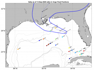
September 2020 - Hurricane Sally
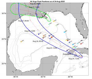
August 2020 - Hurricane Laura and Marco
LC-Floats float missions changed to higher sampling frequency during 2021 hurricane season.
Image from 30 August 2021, Hurricane Ida. http://argo.whoi.edu/solo2/h21_status.html