Ashley Arroyo
September 24, 2022
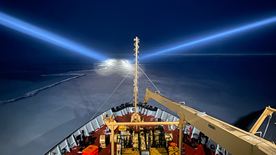
Navigating the ship through the sea-ice is no easy task! Luckily, there are several tools that are utilized by the captain and mates to help make decisions that make traveling through the ice much easier. Of course, the most efficient way to navigate in this region is to avoid the ice, and sail through areas of open water because the ship experiences less resistance going through water than going through ice. Although once we are in mostly ice-covered waters, the Captain and mates try to look for leads, which are gaps between ice pans. When there are no leads, the Captain and mates use the weight of the ship and the momentum created to smash through the ice. As the ship is getting bogged down by ice, the captain and mates typically add more power which helps build more momentum in anticipation of thick ice. The quickest way to get somewhere is not always in a straight line; it usually involves avoiding obstacles including thick, old (multi-year) sea ice, and ridges. Ridges form when two or more pieces of sea-ice collide, causing the ice to curl up/down, resulting in much thicker ice than the surrounding sea-ice. Once the ship has made it through an area of thick ice/ridges, they dial back on the power to maintain a safe speed. Plans to navigate through certain areas of sea-ice do not always follow through- the Captain and mates are able to back out and redirect the ship if a seemingly better path emerges, which happens often!
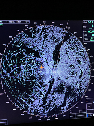
First mate Dan Loghin explained some of the methods that are used to choose the quickest, most efficient route to our science stations, in the presence of sea-ice. One of these tools a detection system known as the radar, which gives insight between types of ice (i.e., older vs. newer ice, different ice textures, etc.), as softer and newer ice is much easier to navigate through in comparison to harder and older sea-ice. However, actual ice conditions can be hard to tell from just the radar on its own but is often used in tactical decision making on short time scales (minutes to hours). Another tool that aids the Captain and mates in navigating through the ice is the satellite image that is produced from Kirsten (the ice specialist we met in dispatch 4!). The satellite image is also used to examine the ice patterns, but they typically use the satellite to make strategic longer-term decisions (days). However, the best tool that is used to navigate through the ice was referred to by Dan as “eyes out the window,” because physically being able to see the ice is the most important thing. By looking out the window, the Captain and mates are about to see what is coming for the next half mile/mile or so and can make quick decisions based on what they see. When the conditions are foggy and visibility is poor, it becomes much more difficult to navigate, and they are left to rely on only the radar and satellite images.
Today, we are anticipating our first ice station, which means the captain and mates are actively looking for ice that is safe for members of the science team to conduct operations on. They are generally looking for a large, flat piece of ice that is a few kilometers in diameter, and able to support the science team hauling equipment across it. We are all very excited to hopefully get a chance to go out onto the ice today!


