On the Origin of Water Masses in the Beaufort Gyre
For details read: Kelly, S. J., Proshutinsky, A., Popova, E. K., Aksenov, Y. K., & Yool, A. (2019). On the origin of water masses in the Beaufort Gyre. Journal of Geophysical Research: Oceans, 124, 4696– 4709. https://doi.org/10.1029/2019JC015022
Link: https://agupubs.onlinelibrary.wiley.com/action/showCitFormats?doi=10.1029%2F2019JC015022
The model used to investigate origin water masses in the Beaufort Gyre region is the Nucleus for European Modelling of the Ocean (NEMO), coupled to the Louvain‐la‐Neuve Ice Model (LIM2) sea ice model (Fichefet & Maqueda, 1997; Goosse & Fichefet, 1999; Madec, 2014). This version of NEMO has 75 depth levels (31 of which are in the top 200 m, with resolution as fine as 1min the uppermost layer), and has a horizontal resolution of approximately 1/12°, giving it a grid length‐scale of 3–5 kmin the Arctic, making it eddy permitting throughout the Arctic, though not fully eddy resolving on the shelves (Nurser & Bacon, 2014).
NEMO is forced at the air‐sea interface using the version 5.2 DRAKKAR forcing set (Brodeau et al., 2010). This includes 6‐hourly winds, temperature and humidity from ERA40 reanalysis, daily longwave and shortwave radiative fluxes, and monthly means for precipitation and river runoff from CORE2 reanalysis. The DRAKKAR forcing set utilizes a monthly climatology for riverine input (Brodeau et al., 2010; Timmermann et al., 2005), with freshwater added at the surface level in this configuration of NEMO. The model was run with this DRAKKAR forcing set forcing between 1958 and 2015.
For our experiments, we employ the ARIANE software (Blanke & Raynaud, 1997) using model output from NEMO. ARIANE works off‐line, reading in the 3‐D velocity fields saved in the NEMO output, interpolating to solve for particle translation through model grid cells, and saving particle positions daily. The output from the global NEMO model used here (run ORCA0083‐N006) is saved as five‐day means. ARIANE can be run both forward and backward in time, and it is the backward tracking that we employ here.
The sources of freshwater for the Arctic Ocean are well established: Siberian and Alaskan Rivers, Pacific Ocean inflow, sea ice meltwater, and precipitation (e.g., (Aagaard & Carmack, 1989). Less is known about the advective pathways associated with these sources and, in particular, the freshwater components by sources in the Beaufort Gyre region. Thus, the goal of this work is to use a Lagrangian particle tracking technique, in conjunction with a high‐resolution ocean model, to investigate water mass (particles representing them) pathways and their temporal variability.
We conducted a set of numerical experiments focusing on the origin of the water in the Beaufort Gyre. To investigate this, we release “particles” throughout the Beaufort Gyre region, and, using the ARIANE software, track them backward for 10 years to their sources. Ten years was chosen to ensure that the majority of particles would have left the gyre within the experiment—this, rather than the time scale to reach each source—is the limiting factor in the experiment. This approach allows us to attribute fractions of the freshwater to the Mackenzie River, Pacific Ocean, and Eurasian shelf, but it does not permit investigation of pathways associated with meltwater or precipitation.
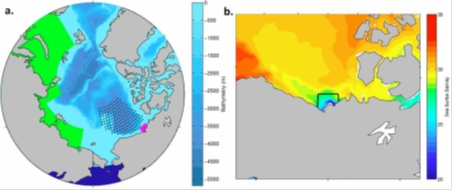
Our Lagrangian particles were initially uniformly distributed over a region bounded by 169°W, 129°W, 81°N, and a southern boundary taken to be the 300‐m depth contour (see Figure 1a for each horizontal release location). We define this to be our “Beaufort Gyre region.” Particles were released at five depth levels: 1, 21, 44, 82, and 140m (chosen to correspond to integer depth levels in NEMO that sample different layers of the Beaufort Gyre). One particle was released at each horizontal location (total of 156 per depth level) and each depth to give a total of 780 particles per release. Releases were performed monthly between 1980 and 2013 (giving a grand total of 9,360 particles per year), and each particle's location was recorded daily for 10 years. Since particle trajectories were followed backward in time, NEMO output was required for the period 1970 to 2013.
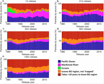
We begin by analyzing the sources of Beaufort Gyre freshwater, and their variability, both temporally and by depth. We start by considering all particles launched in a given year at each depth level. Figure 2 shows a stacked bar chart for each of the release depths, displaying how many particles we attributed to each source (or none at all) for each year.
From Figure 2, it is clear that Pacific Ocean (dark blue) is the dominant source of particles in all years. 34% of all trajectories are tracked back to the Pacific Ocean, and the Pacific dominates most strongly (41% of all trajectories) for releases at 44‐m depth, which is in the Pacific layer of the Beaufort Gyre. We note the trend of the Pacific contribution increasing from the late 1980s and throughout the 1990s, which is especially prominent in the 44‐ and 82‐mreleases. However, it is important to note that this does not necessarily imply that it is the dominant source of freshwater to the Beaufort Gyre—each particle backtracked to the Pacific Ocean represents a much smaller freshwater contribution than a particle backtracked to the Mackenzie River. From observations (Woodgate, 2018), it is known that the freshwater discharge from the Bering Strait (2,000–3,000 km3/year) is an order of magnitude larger than the discharge from the Mackenzie River (300 km3/year), which is in agreement with our experiment results showing that the majority of trajectories can be traced back to the Bering Strait.
The contribution of the Mackenzie River is more important at the surface of the Beaufort Gyre region relative to the Mackenzie contribution at greater depths. Twenty‐seven percent of trajectories from the 1‐m release are tracked to the Mackenzie River; however, this diminishes in importance in the deeper layers (14%, 8%, 6%, and 7% for 21‐, 44‐, 82‐, and 140‐m releases, respectively). In contrast, the contribution of Eurasian shelf waters—including inputs from Eurasian rivers—is negligible in all layers in almost all years investigated (1.6% of all trajectories), aside from a contribution to the surface layer in the early 1980s. Due to the small, typically negligible number of particles reaching the Siberian shelf, we do not attempt to consider the relative contribution of the Siberian rivers but acknowledge this as a potential avenue for future research. The red and orange bars in Figure 2 correspond to those particles which either never leave the gyre (red) or leave but have not yet reached another box (orange).
To summarize, the two main results that we can glean from this analysis of sources of Lagrangian particles are as follows:
- The Beaufort Gyre is strongly layered by advective source. The vertical structure of the Beaufort Gyre region is well described (Davis et al., 2016; Lique et al., 2014; Steele et al., 2004) with a fresh upper layer above the Pacific halocline and finally the Atlantic layer at the bottom. This structure is apparent in Figure 2, with the majority of Mackenzie and some Eurasian particles in the surface release, Pacific particles dominating the 44‐ and 82‐m releases (41% and 40%, respectively), and a marked decline in Pacific particles from the 140‐m release (27%), which corresponds approximately to the base of the Pacific layer in the Canada Basin (Steele et al., 2004).
- The contribution of Pacific water to the Beaufort Gyre has increased since the late 1980s. This trend is most obvious in the 44‐ and 82‐m layers, where the Pacific contribution increased by 43% in these layers between 1988 and 2000. This trend is in agreement with observations which have noted an increase in Pacific inflow to the Arctic via the Bering Strait over the same period (Woodgate, 2018).
References
See paper by Kelly et al. (2019): https://agupubs.onlinelibrary.wiley.com/doi/10.1029/2019JC015022

